Draft:Bell Street
Bell Street Bell-Banksia Link | |
|---|---|
| Coordinates | |
| General information | |
| Type | Road |
| Length | 11.6 km (7.2 mi)[1] |
| Route number(s) |
|
| Major junctions | |
| West end | Pascoe Vale South, Melbourne |
| |
| East end | Heidelberg/Eaglemont |
| Location(s) | |
| Major suburbs | Pascoe Vale South, Coburg, Preston, Heidelberg West, Heidelberg Heights, Bellfield, Heidelberg, Eaglemont |
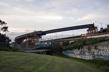
Bell Street is an arterial road in the northern suburbs of Melbourne, Australia. The road begins at CityLink in Pascoe Vale South, traversing the suburbs of Coburg and Preston, acting as the border between Heidelberg West/Heights and Bellfield, before turning into Banksia Street, which is the border between Eaglemont and Heidelberg. The road is 4-6 lanes, carrying heavy traffic.[2][3][4][5][6]
History

The Country Roads Board (later VicRoads) declared Bell Street a Main Road in August 1947,[7] heading west from Main Heidelberg-Eltham Road (today Rosanna Road) along Burgundy and then Bell Streets in Heidelberg through Preston and Coburg to Moonee Ponds Creek at Pascoe Vale South.[7] This was extended further west via a new bridge over Moonee Ponds Creek to connect directly to the Tullamarine Freeway extension when it opened in 1970 (plans to do so had existed since 1950[7]).
Work on the direct link between Bell and Banksia Streets (the "Bell-Banksia Link") in western Heidelberg, built to relieve traffic congestion and improve safety around the Burgundy Street shopping precinct, started in December 1988[8] and was completed on 1 July 1992, at a total cost of $40 million.[9]
Bell Street was connected to the newly created CityLink in 1999.[10] As part of the CityLink–Tulla Widening project which completed in 2018, a dedicated lane from the Tullamarine Freeway to Bell Street was created to reduce weaving. Controversy arose due to the proximity of Strathmore Secondary College to the new ramp at Bell Street.[11]

Major intersections
| LGA | Location[1] | km | mi | Destinations | Notes |
|---|---|---|---|---|---|
| Merri-bek | Pascoe Vale South | 0.0 | 0.0 | Western end of Bell Street | |
| Entry from Pascoe Vale Road eastbound via CityLink ramp | |||||
| Coburg | 2.9 | 1.8 | Upfield railway line | ||
| 3.3 | 2.1 | No right turn westbound to Sydney Road northbound | |||
| 3.5 | 2.2 | Elm Grove, to | |||
| 4.4 | 2.7 | Nicholson Street – Brunswick East | |||
| Darebin | Preston | 6.1 | 3.8 | ||
| 6.3 | 3.9 | Mernda railway line | |||
| 6.6 | 4.1 | ||||
| 6.9 | 4.3 | ||||
| 8.2 | 5.1 | ||||
| Banyule | Bellfield–Heidelberg West–Heidelberg Heights–Ivanhoe quadpoint | 10.5 | 6.5 | Waterdale Road – Heidelberg West, Ivanhoe | |
| Ivanhoe–Heidelberg Heights border | 11.3 | 7.0 | Bell Street – Heidelberg | Eastbound exit only Eastern end of Bell Street, western end of Bell-Banksia Link | |
| Ivanhoe–Heidelberg border | 11.5 | 7.1 | Westbound entrance only | ||
| Heidelberg | 11.9 | 7.4 | Studley Road – Heidelberg, Ivanhoe | Eastern end of Bell–Banksia Link, western end of Banksia Street | |
| 12.0 | 7.5 | Hurstbridge railway line | |||
1.000 mi = 1.609 km; 1.000 km = 0.621 mi
| |||||
References
- ^ a b Google (22 April 2024). "Bell Street" (Map). Google Maps. Google. Retrieved 22 April 2024.
- ^ Hansen Partnership Pty. Ltd. (December 2006). "The Bell Street Corridor Strategy". City of Darebin. Archived from the original on 7 April 2024.
- ^ Build, Victoria’s Big (21 April 2023). "Bell Street, Preston". Victoria’s Big Build. Retrieved 21 April 2024.
- ^ Build, Victoria’s Big (22 June 2022). "Bell Street, Coburg". Victoria’s Big Build. Retrieved 21 April 2024.
- ^ Robb, Kirsten (31 July 2018). "Bell Street bingo: Which northern suburb will be next to get hip?".
- ^ "42 new homes for vulnerable families in Melbourne's inner north". unison.org.au.
- ^ a b c "Country Roads Board Victoria. Thirty-Seventh Annual Report: for the year ended 30 June 1950". Country Roads Board of Victoria. Melbourne: Victorian Government Library Service. 4 December 1950. p. 35.
- ^ "Road Construction Authority of Victoria. Annual Report for the year ended 30 June 1989". Road Construction Authority of Victoria. Melbourne: Victorian Government Library Service. 14 November 1989. p. 45.
- ^ "VicRoads Annual Report 1991-92". VicRoads. Melbourne: Victorian Government Library Service. 30 September 1992. p. 37.
- ^ "Project Overview : CityLink". VicRoads. Archived from the original on 23 July 2008. Retrieved 17 July 2008.
- ^ "Strathmore school says CityLink Tulla project a risk to health and safety". The Age. 7 February 2016. Retrieved 2 October 2016.

