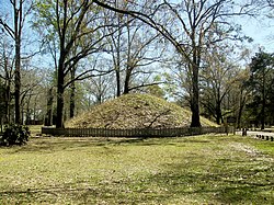
Marksville Prehistoric Indian Site
 Artists conception of the site layout. | |
| Location | Marksville, Louisiana, Avoyelles Parish, Louisiana, |
|---|---|
| Region | Avoyelles Parish, Louisiana |
| Coordinates | 31°7′29″N 92°2′52″W / 31.12472°N 92.04778°W |
| History | |
| Cultures | Marksville culture, Avoyel and Natchez peoples |
| Site notes | |
| Responsible body: State | |
Marksville Prehistoric Indian Site | |
| Architect | Unknown |
| NRHP reference No. | 66000372 |
| Significant dates | |
| Added to NRHP | October 15, 1966[1] |
| Designated NHL | July 19, 1964[2] |
Marksville Prehistoric Indian Site (16 AV 1), also known as the Marksville State Historic Site, is a Marksville culture archaeological site located 1 mile (1.6 km) southeast of Marksville in Avoyelles Parish, Louisiana. The site features numerous earthworks built by the prehistoric indigenous peoples of southeastern North America.
Description

Marksville is the type site for the Marksville culture (a local variation of the Hopewell tradition) and was the first scientifically excavated site for the culture. Centuries later the Avoyel and Natchez peoples lived in the vicinity of the site until 1700.[3] Burial mounds at the site are surrounded by a horseshoe-shaped earthen embankment about 3,000 feet (910 m) long. The site is also one of the largest of the period in the southeastern United States, with large and distinctive ring features not found elsewhere. The site's importance has been known since the 1920s, when it was first formally investigated, and it is regularly the subject of further investigation. Radiometric dating of the sites features have yielded occupancy dates from 0-400 CE.[4]
Landmark and access
The archaeological site was declared a National Historic Landmark in 1964.[2][5] The site is now also a State Commemorative Area.
The 42-acre (170,000 m2) site is maintained by the state of Louisiana and features a museum with artifacts found at the site and exhibits about the prehistoric people that lived in the Marksville culture area.[6] There are also trails to the mounds and picnic facilities.
As of July 2018, the park is not open to the public and can only be accessed with a two-week advance notice to the Louisiana State Parks' district office.
See also
- Crooks mound
- Grand Gulf Mound
- List of Hopewell sites
- List of National Historic Landmarks in Louisiana
- National Register of Historic Places listings in Avoyelles Parish, Louisiana
References
- ^ "National Register Information System". National Register of Historic Places. National Park Service. January 23, 2007.
- ^ a b "Marksville Prehistoric Indian Site". National Historic Landmark summary listing. National Park Service. Retrieved 2008-01-04.
- ^ Louisiana Department of Culture, Recreation and Tourism. "Marksville Indian Museum Historical Marker".
- ^ McGimsey, Chip (Summer 2003). "The Rings of Marksville". Southeastern Archaeology (Volume 22, No. 1): 47–62. JSTOR 40713264.
{{cite journal}}:|issue=has extra text (help) - ^ Griffin, John W. (February 28, 1964). "National Survey of Historic Sites and Buildings: Marksville" (pdf). National Park Service.
{{cite journal}}: Cite journal requires|journal=(help) and Accompanying photos, exterior and interior, from 19. (32 KB) - ^ "Louisiana Prehistory-Marksville, Troyville-Coles Creek, and Caddo". Archived from the original on 2008-12-15. Retrieved 2010-02-04.
{{cite web}}: Unknown parameter|deadurl=ignored (|url-status=suggested) (help)
External links
- Marksville State Historic Site - Louisiana Office of State Parks - Official Page
- Jones, Dennis (1991). Weinsten, Richard A. (ed.). "The Avoyelles Prairie Terrace : Concentrated Archaeology" (PDF). Louisiana Archaeological Society Newsletter. 18 (1). Louisiana Archaeological Society: 10–15. Archived from the original (PDF) on 2014-04-15.
{{cite journal}}: Unknown parameter|deadurl=ignored (|url-status=suggested) (help)
- Marksville culture
- Native American museums in Louisiana
- Archaeological museums in Louisiana
- Museums in Avoyelles Parish, Louisiana
- Mounds in Louisiana
- National Historic Landmarks in Louisiana
- Louisiana State Historic Sites
- Archaeological type sites
- Protected areas of Avoyelles Parish, Louisiana
- Archaeological sites on the National Register of Historic Places in Louisiana
- National Register of Historic Places in Avoyelles Parish, Louisiana


