Tur Abdin

Tur Abdin (Syriac:ܛܘܪ ܥܒܕܝܢ) is a hilly region of south east Turkey incorporating the eastern half of Mardin Province, and Sirnak Province west of the Tigris, on the border with Syria. The name 'Tur Abdin' is from the Syriac language meaning 'mountain of the servants (of God)'. Tur Abdin is of great importance to Syriac Orthodox Christians, for whom the region used to be a monastic and cultural heartland. The Assyrian/Syriac of Tur Abdin call themselves Suryoye something they share with their brethren Nestorian and Chaldean Assyrians and traditionally speak the Aramaic dialect recently called Turoyo but originally called "Surayt" in their mother tongue.
Monastery


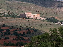
The most important Syriac Orthodox centre in Tur Abdin is the monastery of Dayro d-Mor Hananyo, 6 km south east of Mardin, in the west of the region. Built from yellow rock, the monastery is affectionately known as Dayro d-Kurkmo in Syriac, Dayr al-Zafaran in Arabic, or Deyrülzafarân in Turkish: the Safron Monastery. Founded in AD 493, the monastery was the residence of the Syriac Orthodox Patriarch from 1160 to 1932. Although the patriarch now lives in Damascus the monastery still contains the patriarchal throne and tombs of seven patriarchs and metropolitans. Today the monastery is lead by a bishop and a monk and some lay assistants, and is a school for orphans. The bishop of Mor Hananyo is also the patriarchal vicar of Mardin. His goal is to rebuild the monastery and to preserve the history of the Syriac Orthodox church. The Dayro d-Mor Hananyo is part of the UNESCO wold cultural heritage and was visited by numerous celebrities e.g. like Prince Charles.
In the centre of Tur Abdin, halfway between Midyat and Cizre, is Dayro d-Mor Gabriel. Built in AD 397, Mor Gabriel monastery, is the oldest functioning Syriac Orthodox monastery. It is the residence of the Metropolitan Bishop of Tur Abdin, seven nuns, four monks and a host of guests, assistants and students. The monastery is charged with keeping the flame of Syriac Orthodox faith alive in Tur Abdin, for which it is as much a fortress as a church.
History

The town of Midyat and the villages of Hah, Bequsyone, Dayro da-Slibo, Salah (with the old monastery of Mor Yaqub), `Aynwardo (with Mor Huschabo), Anhel, Kafro, Arkah (Harabale, with Dayro Mor Malke), Beth Sbirino, Middo (Miden) and Azagh were all important Syriac Orthodox places. Hah has the ancient `Idto d'Yoldath-Aloho, the Church of the Mother of God.
During the First World War, many Assyrian/Syriac, some 500,000 (according to Syriac Orthodox records, ca. 90.000 of their community were included), were killed in the Armenian and Assyrian/Syriac Genocide (called in Syriac Sayfo, simply 'the sword') and died alongside their coreligionists. In the last few decades, caught between Kurds and Turks, many Assyrians/Syriacs have fled the region or been killed. Today there are only 2,500, a quarter of the Christian population thirty years ago. Most have fled to Syria, Europe (particularly Sweden, Germany, the UK and the Netherlands), Australia and the USA. However, in the past few years, a few families have begun to return to Tur Abdin.
On 10 February 2006 and the following day, large demonstrations took place in the city of Midyat in Tur Abdin. Muslims angry about the Jyllands-Posten Muhammad cartoons gathered in Estel, the new part of the city, and started to march towards the old part of Midyat (6 kilometers away), where the Christians live. The mob was stopped by the police before reaching Midyat.
See also
External links
- The Diocese of Linz Eastern Christian Initiative and the Friends of Tur Abdin Template:De icon
- Maps of Tur Abdin
- Margonitho - Syriac Orthodox Resources (see Churches & Monasteries, History and the Rev Stephen Griffith Reports from Tur Abdin)
