
Wattle Grove, New South Wales
| Wattle Grove Sydney, New South Wales | |||||||||||||||
|---|---|---|---|---|---|---|---|---|---|---|---|---|---|---|---|
 Wattle Grove Plaza | |||||||||||||||
| Population | 9,586[1] | ||||||||||||||
| Established | 1990 | ||||||||||||||
| Postcode(s) | 2173 | ||||||||||||||
| Location | 30 km (19 mi) south-west of Sydney CBD | ||||||||||||||
| LGA(s) | City of Liverpool | ||||||||||||||
| State electorate(s) | Menai | ||||||||||||||
| Federal division(s) | Hughes | ||||||||||||||
| |||||||||||||||
Wattle Grove is a suburb of Sydney, in the state of New South Wales, Australia. Wattle Grove is located 30 kilometres south-west of the Sydney central business district in the local government area of the City of Liverpool.
Wattle Grove is a residential suburb with a small shopping centre and a number of recreational areas such as Wattle Grove Park, Lakeside Park and Australis Park. Anzac Village is a locality across the northern part of Wattle Grove and Holsworthy.
History
Wattle Grove was built on former Australian Defence Force land. The original plans for a suburb were made by the government of Prime Minister Gough Whitlam in the 1970s. Infrastructure was built and the suburb lay dormant until further developed by Delfin [2] in the 1990s. The suburb name was officially changed from Holsworthy Village to Wattle Grove in 1992.[3]
In 2006, Wattle Grove's tree-lined streets underwent significant change. Many of the casuarina trees (Australian Pine) that lined the main road were replaced, due to roots potentially damaging nearby houses or falling during storms. Native shrubs have been planted in their place.
Commercial area
Wattle Grove's shopping centre was opened in 1998, but in late 2005 several of the businesses were gutted by fire. The centre reopened in 2007 and includes a Coles supermarket, Gloria Jean's Coffees, Michel's Patisserie, hairdressing salon, fruit shop, real estate agency, pizzeria, pharmacy, charcoal chicken, newsagency and other specialty shops. The Wattle Grove Club Hotel is within the complex.
-
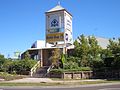 Wattle Grove Pub
 -
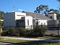 St. Thomas' Indian Orthodox Church, Village Way


Churches
A chapel of The Church of Jesus Christ of Latter-day Saints and St. Thomas' Indian Orthodox Church are located in Wattle Grove. St Christophers Catholic Church at Holsworthy also services the Wattle Grove area.
Anglican churches local to Wattle Grove are St. Anne's Hammondville and St. Thomas' Moorebank.
Climate
| Climate data for Wattle Grove | |||||||||||||
|---|---|---|---|---|---|---|---|---|---|---|---|---|---|
| Month | Jan | Feb | Mar | Apr | May | Jun | Jul | Aug | Sep | Oct | Nov | Dec | Year |
| Mean daily maximum °C (°F) | 29.1 (84.4) |
28.2 (82.8) |
26.3 (79.3) |
23.5 (74.3) |
20.6 (69.1) |
18 (64) |
17.3 (63.1) |
18.9 (66.0) |
22.4 (72.3) |
24.5 (76.1) |
25.1 (77.2) |
27.7 (81.9) |
23.5 (74.3) |
| Mean daily minimum °C (°F) | 17.4 (63.3) |
17.4 (63.3) |
15.5 (59.9) |
12.1 (53.8) |
8.3 (46.9) |
6.1 (43.0) |
4.8 (40.6) |
5.6 (42.1) |
8.6 (47.5) |
10.9 (51.6) |
13.5 (56.3) |
15.8 (60.4) |
11.3 (52.3) |
| Source: BOM[4] | |||||||||||||
Community
The Wattle Grove area was designed to have a strong community 'feel' under the redeveloping of the area by Delfin in the 1990s.
Today, it is possible to evaluate the success of this by the large numbers of young families walking the tree lined footpaths on the weekends, and the strong turnouts at community events, such as the Christmas Carols and the Annual Easter Egg Hunt in Australis Park on Easter Sunday.
Schools
Wattle Grove is served by three primary schools: Holsworthy Primary School, Wattle Grove Primary School and St Christopher's Catholic Primary School, in addition to secondary schools: Holsworthy High School, Moorebank High School and St Marks Coptic Orthodox College.
St Christopher's is a feeder school for All Saints Catholic Girls and Boys Schools in Liverpool.
Transport
Wattle Grove is well connected to other regions of Sydney due to its proximity to the M5 and M7 Motorways. Bus routes 901 and 902, operated by Veolia Transport, run within the suburb. Route 901 connects to Holsworthy railway station and Liverpool railway station.
Wattle Grove Lake
Wattle Grove Lake is in Lakeside Park. It is home to lots of water birds.
Sport and recreation
Playgrounds are located throughout the suburb, as well as walking and bike paths leading to an artificial lake. Moorebank Sports Club, located nearby, provides opportunities for formal training in Rugby League, Soccer, Hockey Baseball, Cricket, Australian Rules Football and Netball. The Sporting codes are associated with Moorebank Sports Club, all being in the same complex except Hockey and AFL which are located in other premises.
-
 Anzac Creek
 -
 Anzac Creek


References
- ^ Australian Bureau of Statistics (9 March 2006). "Wattle Grove (State Suburb)". 2001 Census QuickStats. Retrieved 17 September 2007.
- ^ Delfin
- ^ http://www.liverpool.nsw.gov.au/ourcity/historicaltimeline.htm Liverpool History
- ^ BOM—Canadian Climate Normals 1971–2000, accessed 07 July 2009
External links
- Home Values in Wattle Grove
- Fire Brigade Archives
- Coptic Orthodox Schools in Sydney
- Wattle Grove Public School Website
- Holsworthy Public School Website
- Holsworthy High School Website
- St. Christophers Catholic Primary School
- Saint Mark's Coptic College Orthodox College Website
- Holsworthy Junior AFL Website
- Moorebank Cricket Club Website
- Mathematics Tutoring in Wattle Grove