1970 Mount Everest disaster
Appearance

| Mount Everest | |
|---|---|
 | |
| Highest point | |
| Elevation | 8,848 m (29,029 ft) |
| Coordinates | 27°59′17″N 86°55′31″E / 27.98806°N 86.92528°E |
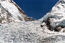
On 5 April 1970, six Nepalese Sherpas died on Mount Everest. The deaths were caused by an ice-fall avalanche in the Khumbu Icefall.[1] The icefall, which lies between Base Camp and Camp I, has been the site of numerous fatalities, including those in the 2014 Mount Everest ice avalanche.[2] The Sherpas were assisting the Japanese Skiing Expedition, which included Yuichiro Miura, the first person to ski down Everest.[3] Their names were Mima Norbu, Nima Dorje, Tshering Tarkey, Pasang, Kunga Norbu, and Kami Tshering.[4] Another death occurred in the Japanese expedition four days later when Kyak Tsering was killed by ice falling from a serac.[3]
See also
- The Man Who Skied Down Everest
- List of deaths on the Eight Thousanders
- 1974 Everest Disaster (French West ridge expedition)
- List of Mount Everest expeditions
- 2014 Mount Everest ice avalanche
References
- ^ Unsworth, Walt (2000). Everest: The Mountaineering History. Seattle, WA: Walk Unsworth. p. 398. ISBN 1-898573-40-9.
- ^ Associated Press (18 April 2014). "Mount Everest avalanche sweeps away Nepalese guides". The Guardian (London).
- ^ a b "THE JAPANESE MOUNT EVEREST EXPEDITION, 1969-1970".
- ^ "Everest Fatalities". adventurestats.com. Archived from the original on 13 June 2011. Retrieved 9 June 2011.
{{cite web}}: Unknown parameter|deadurl=ignored (|url-status=suggested) (help)

