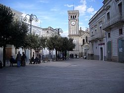
Miglionico
Miglionico | |
|---|---|
| Comune di Miglionico | |
 | |
| Coordinates: 40°34′N 16°30′E / 40.567°N 16.500°E | |
| Country | Italy |
| Region | Basilicata |
| Province | Matera (MT) |
| Government | |
| • Mayor | Francesco Comanda |
| Area | |
• Total | 88.84 km2 (34.30 sq mi) |
| Elevation | 465 m (1,526 ft) |
| Population (2018-01-01)[2] | |
• Total | 2,461 |
| • Density | 28/km2 (72/sq mi) |
| Demonym | Miglionichesi |
| Time zone | UTC+1 (CET) |
| • Summer (DST) | UTC+2 (CEST) |
| Postal code | 75010 |
| Dialing code | 0835 |
| Patron saint | St. Peter |
| Saint day | June 29 |
| Website | Official website |
Miglionico (Lucano: Megghiuòneche) is a town and comune in the province of Matera, in Basilicata, southern Italy.
Main sights
- The massive Castello del Malconsiglio ("Castle of the Bad Council"), built in the 8th-9th century and enlarged in 1110 and in the 15th century.
- The Basilica of Santa Maria Maggiore.
History
Despite the legend assigning its foundation to the famous Greek wrestler Milo of Croton (whence the name), Miglionico was most likely founded by the Oenotrians, a local Italic tribe. After the Greek colonization, it was held by the Lucani, followed by the Samnites until 458 BC, when it was conquered by the Romans.
In the Middle Ages the story of Miglionico was strongly connected to that of its large castle, which was held by the Hauteville Normans and then by the Sanseverino. After the latter where slaughtered by order of Frederick II (1245), Miglionico was assigned to his son Manfred. After the latter's fall, however, the Sanseverino were re-instated, holding the town until the abolition of feudalism.
References
- ^ "Superficie di Comuni Province e Regioni italiane al 9 ottobre 2011". Italian National Institute of Statistics. Retrieved 16 March 2019.
- ^ "Popolazione Residente al 1° Gennaio 2018". Italian National Institute of Statistics. Retrieved 16 March 2019.
External links


