Venkojipalem
Appearance
Venkojipalem | |
|---|---|
Neighbourhood | |
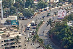
 Venkojipalem junction from Kailasagiri. | |
| Coordinates: 17°44′44″N 83°19′44″E / 17.745550°N 83.328927°E | |
| Country | |
| State | Andhra Pradesh |
| District | Visakhapatnam |
| Government | |
| • Body | Greater Visakhapatnam Municipal Corporation |
| Languages | |
| • Official | Telugu |
| Time zone | UTC+5:30 (IST) |
| PIN | 530022 |
| Vehicle Registration | AP31, AP32, AP33 (Former) AP39 (from 30 January 2019)[1] |
Venkojipalem is a locality in Visakhapatanam City in Andhra Pradesh State, India. It belongs to Andhra region. Venkojipalem is divided into New Venkojipalem and Old Venkojipalem.[2]
Features
Durga Nagar (1 km), HB Colony (1 km), Maddilapalem (1 km), Appughar (1 km), and Hanumanthawaka (1 km) are the nearby localities to Venkojipalem.
Commerce
The shopping area is quite old and new can usually fulfill the need of its nearby residents. Shops in the form of free standing rental areas still exist here.
Transport
APSRTC runs the buses to this suburb, connecting it to all parts of the city.
Education
There are a good number of schools and colleges for all budgets.
References
- ^ "New 'AP 39' code to register vehicles in Andhra Pradesh launched". The New Indian Express. Vijayawada. 31 January 2019. Retrieved 9 June 2019.
- ^ "location". maps of india. 25 August 2014. Retrieved 12 September 2014.

