Bystřice nad Pernštejnem
Bystřice nad Pernštejnem | |
|---|---|
Town | |
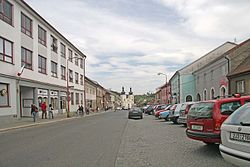
 Main square | |
| Coordinates: 49°31′23″N 16°15′41″E / 49.52306°N 16.26139°E | |
| Country | |
| Region | Vysočina |
| District | Žďár nad Sázavou |
| First mentioned | 1298 |
| Government | |
| • Mayor | Karel Pačiska |
| Area | |
| • Total | 53.08 km2 (20.49 sq mi) |
| Elevation | 535 m (1,755 ft) |
| Population (2020-01-01[1]) | |
| • Total | 8,004 |
| • Density | 150/km2 (390/sq mi) |
| Time zone | UTC+1 (CET) |
| • Summer (DST) | UTC+2 (CEST) |
| Postal code | 593 01 |
| Website | www.bystricenp.cz |
Bystřice nad Pernštejnem (Czech pronunciation: [ˈbɪstr̝̊ɪtsɛ ˈnat pɛrnʃtɛjnɛm]; German: Bistritz ob Pernstein) is a town in the Vysočina Region, Czech Republic. It has a population of about 8,000.
History
It was established in the 13th century and got it was named after river Bystřice. The first written record about the Bystřice can be traced back to 1298. In the 14th century it became the economic and commercial center of the surrounding villages in Pernštejn dominion. Rudolf II promoted Bystřice to town in 1580. By this occasion the town received its coat of arms. The owners of the town changed frequently after 1588 when it was sold by Jan from Pernštejn.
In 1905 the town was connected by railway with Žďár nad Sázavou and Tišnov which contributed to development of local industry. The town also benefited from the development of uranium industry in Dolní Rožínka. In 1925 Bystřice was renamed to 'Bystřice nad Pernštejnem'. In 2010 the town square was renovated.
Administrative parts
The town has following parts: Divišov, Dvořiště, Bratrušín, Domanínek, Domanín, Karasín, Kozlov, Lesoňovice, Pivonice, Rovné and Vítochov.
Population
|
| |||||||||||||||||||||||||||||||||||||||||||||
| Source: [2] | ||||||||||||||||||||||||||||||||||||||||||||||
Notable people
- Otto Eisler (1893–1968), architect
Twin towns – sister cities
Bystřice nad Pernštejnem is twinned with:[3]
 Boguchwała, Poland
 Crimmitschau, Germany
 Vranov nad Topľou, Slovakia
Gallery
-
The lower part of the town square
-
A view at the upper part of the town square
-
Saint Lawrence of Rome Church
-
Plague column on the town square
References
- ^ "Population of Municipalities – 1 January 2020". Czech Statistical Office. 30 April 2020.
- ^ Balcar, Vladimír; Havel, Radek; Křídlo, Josef; Pavlíková, Marie; Růžková, Jiřina; Šanda, Robert; Škrabal, Josef (2006): Historický lexikon obcí České republiky 1869–2005. Český statistický úřad, Praha, ISBN 80-250-1311-1.
- ^ "Partnerská města" (in Czech). Město Bystřice nad Pernštejnem. Retrieved 22 July 2020.
External links
 Media related to Bystřice nad Pernštejnem at Wikimedia Commons


