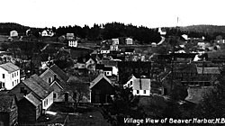
Beaver Harbour, New Brunswick
Appearance
Beaver Harbour | |
|---|---|
 Beaver Harbour in 1920 | |
| Coordinates: 45°04′23″N 66°44′34″W / 45.07306°N 66.74278°W | |
| Country | |
| Province | |
| County | Charlotte |
| Electoral Districts Federal | New Brunswick Southwest |
| Provincial | Charlotte-The Isles |
| Time zone | UTC-4 (AST) |
| • Summer (DST) | UTC-3 (ADT) |
| Postal code(s) | |
| Area code | 506 |
| Highways | |
Beaver Harbour is a community on the Fundy shore of New Brunswick, Canada.
Most of the community forms the Local service district of Beaver Harbour, which was established in 1971.[1] It is also a census subdivision of Census Canada. Since the formation of the LSD, the community has expanded past the original boundaries into the LSD of the parish of Pennfield.[citation needed]
In 1866 it had about 30 resident families, and grew to a population of 150 by 1871, the 500 in 1898.[2] As of 2016, the population was 277.[3]
It is the site of the Lighthouse Point Light, originally built in 1875 and subsequently rebuilt. It is a fiberglass tapered cylindrical tower with balcony and lantern.[4]
References
- ^ "Regulation 71-17 under the Municipalities Act (O. C. 71-127)". The Royal Gazette. 129. Fredericton, NB, Canada: 154. 3 March 1971. Filed February 17, 1971.
- ^ "Beaver Harbour". Provincial Archives of New Brunswick. Retrieved 22 June 2020.
- ^ "Beaver Harbour, Local service district [Designated place], New Brunswick and New Brunswick [Province]". Satistics Canada. Retrieved 22 June 2020.
- ^ "Lighthouse Point Lighthouse". LighthouseFriends. Retrieved 22 June 2020.

