Nelson Dewey State Park
Tools
Actions
General
Print/export
In other projects
Appearance
From Wikipedia, the free encyclopedia
This is an old revision of this page, as edited by Monkbot (talk | contribs) at 17:10, 25 January 2021 (Task 18 (cosmetic): eval 2 templates: hyphenate params (2×);). The present address (URL) is a permanent link to this revision, which may differ significantly from the current revision.
Revision as of 17:10, 25 January 2021 by Monkbot (talk | contribs) (Task 18 (cosmetic): eval 2 templates: hyphenate params (2×);)
| Nelson Dewey State Park | |
|---|---|
IUCN category V (protected landscape/seascape) | |
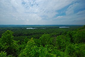
 Dewey Heights Prairie, Nelson Dewey State Park, May 2011 | |
| Location | Grant, Wisconsin, United States |
| Coordinates | 42°43′51″N 91°1′10″W / 42.73083°N 91.01944°W / 42.73083; -91.01944 |
| Area | 756 acres (306 ha) |
| Established | 1935 |
| Named for | Nelson Dewey |
| Governing body | Wisconsin Department of Natural Resources |
| Website | Nelson Dewey State Park |
Nelson Dewey State Park is a 756-acre (306 ha) Wisconsin state park on the Mississippi River. The land was once part of the Stonefield estate of Nelson Dewey, the state's first governor.
Activities and amenities
- Trails: The park offers 2 miles (3.2 km) of hiking trails with bluff-top views of the Mississippi River Valley.[1]
- Camping: The campground has 45 sites, four of them walk-in sites located along the top of the bluffs.[2]
References
- ^ "Nelson Dewey State Park: Activities and recreation". Wisconsin DNR. March 25, 2013. Retrieved September 5, 2013.
- ^ "Nelson Dewey State Park: Camping". Wisconsin DNR. September 5, 2013. Retrieved September 5, 2013.
External links
- Nelson Dewey State Park Wisconsin Department of Natural Resources


