Morowali Regency
Morowali Regency
Kabupaten Morowali | |
|---|---|
| Motto(s): Tepe Asa Maroso (Pamona) (United We Are Firm) | |
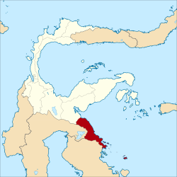
 Location within Central Sulawesi | |
| Coordinates: 2°49′07″S 121°51′39″E / 2.818536°S 121.860786°E | |
| Country | Indonesia |
| Province | Central Sulawesi |
| Capital | Bungku |
| Government | |
| • Regent | Anwar Hafid |
| • Vice Regent | Marunduh |
| Area (as reduced by the separation of North Morowali) | |
| • Total | 4,135.36 km2 (1,596.67 sq mi) |
| Population (2010)(on 2013 boundaries) | |
| • Total | 102,228 |
| • Density | 25/km2 (64/sq mi) |
| Time zone | UTC+8 (ICST) |
| Area code | (+62) 464/465 |
| Website | morowalikab |
Morowali Regency is a regency of Central Sulawesi Province of Indonesia. The administrative centre is at the town of Bungku. The Regency includes the far-flung Menui Islands (Kepulauan Menui), lying to the southwest of the rest of the province.
History
In 1999, Morowali Regency was created out of a portion of Poso Regency.[1] It was composed of the southeastern fourteen districts of the former Poso Regency.
In 2013 this Morowali Regency was in turn divided into two Regencies. The seven northernmost districts were split off to form a new North Morowali Regency (Morowali Utara). The seven southernmost districts were retained as the residual Morowali Regency.
Administration
The Morowali Regency is divided (since the creation of the separate North Morowali Regency in 2013) into seven districts (kecamatan), tabulated below with their 2010 Census population.[2]
| Name | Area in km2 |
Population Census 2010 |
|---|---|---|
| Menui Kepulauan (Menui Islands) |
213.60 | 12,064 |
| Bungku Selatan (South Bungku) |
462.83 | 17,273 |
| Bahodopi | 1,119.52 | 6,594 |
| Bungku Tengah (Central Bungku) |
977.96 | 27,774 |
| Bungku Barat (West Bungku) |
417.24 | 10,093 |
| Bumi Raya | 132.03 | 11,488 |
| Wita Pondo | 812.18 | 16,942 |
References
- ^ Sangadji, Ruslan (21 February 2007). "Residents say a divided Poso could be a more peaceful place". The Jakarta Post.
- ^ Biro Pusat Statistik, Jakarta, 2011.


