Skipsea Brough
Appearance
| Skipsea Brough | |
|---|---|
 | |
Location within the East Riding of Yorkshire | |
| OS grid reference | TA162546 |
| Civil parish | |
| Unitary authority | |
| Ceremonial county | |
| Region | |
| Country | England |
| Sovereign state | United Kingdom |
| Post town | DRIFFIELD |
| Postcode district | YO25 |
| Dialling code | 01262 |
| Police | Humberside |
| Fire | Humberside |
| Ambulance | Yorkshire |
| UK Parliament | |
Skipsea Brough is a hamlet in the East Riding of Yorkshire, England. It is situated approximately 5 miles (8 km) north of Hornsea on the B1249 road.
It forms part of the civil parish of Skipsea.

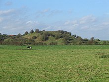
Skipsea Brough is the location of Skipsea Castle which was built about 1086. The motte-and-bailey castle's buildings have since been destroyed, however, impressive earthworks still remain.[1] In 2016 it was reported that the castle was itself built on top of a large Iron Age mound.[2]
References
[edit]- ^ Historic England. "Skipsea Castle (80781)". Research records (formerly PastScape). Retrieved 23 October 2007.
- ^ "Skipsea Castle was built on Iron Age mound, excavation reveals", The Guardian, 3 October 2016, retrieved 3 October 2016
- Gazetteer — A–Z of Towns Villages and Hamlets. East Riding of Yorkshire Council. 2006. p. 10.
Wikimedia Commons has media related to Skipsea Brough.

