Tiburon, Haiti
Appearance
Tiburon
Tibiwon | |
|---|---|
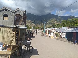
 View of Tiburon, along Route National 2 | |
Location in Haiti[1] | |
| Coordinates: 18°20′0″N 74°24′0″W / 18.33333°N 74.40000°W | |
| Country | Haiti |
| Department | Sud |
| Arrondissement | Chardonnières |
| Area | |
| • Total | 154.0 km2 (59.5 sq mi) |
| Elevation | 65 m (213 ft) |
| Population (2009) | |
| • Total | 21,170 |
| • Density | 137.47/km2 (356.0/sq mi) |
Tiburon (Template:Lang-ht) is a coastal commune in the Chardonnières Arrondissement, in the Sud department of Haiti. It has 21,170 inhabitants.[2] It is situated in a valley, at the mouth of the Tiburon River.
Geology
The valley of the Tiburon River, and the town of Tiburon sit exactly on the Enriquillo–Plantain Garden fault.
Settlements
References
- ^ "National Geospatial-Intelligence Agency". GeoNames Search. Retrieved 29 August 2014.
- ^ "IHSI" (PDF). INSTITUT HAÏTIEN DE STATISTIQUE ET D’INFORMATIQUE. Retrieved 30 August 2014.


