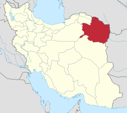
Davarzan County
Appearance
Davarzan County
| |
|---|---|
County | |
 Location of Davarzan County in Razavi Khorasan province | |
 Location of Razavi Khorasan province in Iran | |
| Coordinates: 36°18′12″N 57°05′36″E / 36.30333°N 57.09333°E[1] | |
| Country | Iran |
| Province | Razavi Khorasan |
| Capital | Davarzan |
| Districts | Central, Bashtin |
| Area | |
• Total | 2,420 km2 (930 sq mi) |
| Population (2016)[2] | |
• Total | 21,911 |
| • Density | 9.1/km2 (23/sq mi) |
| Time zone | UTC+3:30 (IRST) |
Davarzan County (Template:Lang-fa) is in Razavi Khorasan province, Iran. Its capital is the city of Davarzan.
At the 2006 census, the region's population (as Davarzan District of Sabzevar County) was 22,406 in 6,763 households.[3] The following census in 2011 counted 21,309 people in 7,154 households.[4] It was separated from Sabzevar County on 15 May 2012.[5] At the 2016 census, the county's population was 21,911 in 7,678 households.[2]
Administrative divisions
The population history and structural changes of Davarzan County's administrative divisions over three consecutive censuses are shown in the following table. The latest census shows two districts, four rural districts, and one city.[2]
| Administrative Divisions | 2006[3] | 2011[4] | 2016[2] |
|---|---|---|---|
| Central District | 16,982 | 16,457 | 11,947 |
| Kah Rural District | 8,531 | 8,213 | 3,771 |
| Mazinan Rural District | 6,064 | 5,542 | 5,432 |
| Davarzan (city) | 2,387 | 2,702 | 2,744 |
| Bashtin District | 5,424 | 4,852 | 9,964 |
| Bashtin Rural District | 5,424 | 4,852 | 4,291 |
| Mehr Rural District | 5,673 | ||
| Total | 22,406 | 21,309 | 21,911 |
| 1As a part of Sabzevar County at the 2006 and 2011 censuses | |||
Wikimedia Commons has media related to Davarzan County.
References
- ^ OpenStreetMap contributors (28 April 2023). "Davarzan County" (Map). OpenStreetMap. Retrieved 28 April 2023.
- ^ a b c d "Census of the Islamic Republic of Iran, 1395 (2016)". AMAR (in Persian). The Statistical Center of Iran. p. 09. Archived from the original (Excel) on 2 April 2022. Retrieved 19 December 2022.
- ^ a b "Census of the Islamic Republic of Iran, 1385 (2006)". AMAR (in Persian). The Statistical Center of Iran. p. 09. Archived from the original (Excel) on 20 September 2011. Retrieved 25 September 2022.
- ^ a b "Census of the Islamic Republic of Iran, 1390 (2011)" (Excel). Iran Data Portal (in Persian). The Statistical Center of Iran. p. 09. Retrieved 19 December 2022.
- ^ "Decree on the organization of Razavi Khorasan Province". Majlis of Iran. 15 May 2012. Archived from the original on 4 March 2016. Retrieved 5 August 2016.

