Torbat-e Heydarieh County
Torbat-e Heydarieh County
Persian: شهرستان تربت حیدریه | |
|---|---|
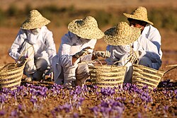
 Harvesting saffron, the main agricultural product of this county | |
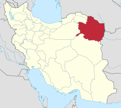
 Location of Torbat-e Heydarieh County in Razavi Khorasan province (center, pink) | |
 Location of Razavi Khorasan province in Iran | |
| Coordinates: 35°25′N 59°09′E / 35.417°N 59.150°E[1] | |
| Country | |
| Province | Razavi Khorasan |
| Capital | Torbat-e Heydarieh |
| Districts | Central, Bayg, Jolgeh Rokh, Kadkan |
| Area | |
• Total | 3,681 km2 (1,421 sq mi) |
| Population (2016)[2] | |
• Total | 224,626 |
| • Density | 61/km2 (160/sq mi) |
| Time zone | UTC+3:30 (IRST) |
| Torbat-e Heydarieh County at GEOnet Names Server | |
Torbat-e Heydarieh County (Persian: شهرستان تربت حیدریه)[a] is in Razavi Khorasan province, Iran. Its capital is the city of Torbat-e Heydarieh.[3]
History
[edit]After the 2006 National Census, Jolgeh Zaveh District was separated from the county in the establishment of Zaveh County.[4] After the 2016 census, the village of Nasar was elevated to the status of a city.[5]
Demographics
[edit]Population
[edit]At the time of the 2006 census, the county's population was 261,917, in 67,735 households.[6] The following census in 2011 counted 210,390 people in 60,777 households.[7] The 2016 census measured the population of the county as 224,626 in 68,927 households.[2]
Administrative divisions
[edit]Torbat-e Heydarieh County's population history and administrative structure over three consecutive censuses are shown in the following table.
| Administrative Divisions | 2006[6] | 2011[7] | 2016[2] |
|---|---|---|---|
| Central District | 150,643 | 166,313 | 179,084 |
| Bala Velayat RD | 20,908 | 24,381 | 27,133 |
| Pain Velayat RD | 10,375 | 10,782 | 11,932 |
| Torbat-e Heydarieh (city) | 119,360 | 131,150 | 140,019 |
| Bayg District | 8,327 | 7,161 | 6,937 |
| Bayg RD | 4,367 | 3,584 | 3,392 |
| Bayg (city) | 3,960 | 3,577 | 3,545 |
| Jolgeh Rokh District | 24,886 | 24,705 | 25,748 |
| Bala Rokh RD | 7,483 | 7,565 | 7,825 |
| Miyan Rokh RD | 5,903 | 6,162 | 5,686 |
| Pain Rokh RD | 10,156 | 9,257 | 10,686 |
| Nasar (city)[b] | |||
| Robat-e Sang (city) | 1,344 | 1,721 | 1,551 |
| Jolgeh Zaveh District[c] | 66,206 | ||
| Safaiyeh RD | 12,711 | ||
| Soleyman RD | 27,332 | ||
| Zaveh RD | 17,423 | ||
| Dowlatabad (city) | 8,740 | ||
| Kadkan District | 11,855 | 12,031 | 12,805 |
| Kadkan RD | 5,107 | 5,147 | 5,941 |
| Roqicheh RD | 3,582 | 3,096 | 3,145 |
| Kadkan (city) | 3,166 | 3,788 | 3,719 |
| Total | 261,917 | 210,390 | 224,626 |
| RD = Rural District | |||
Geography
[edit]Torbat-e Heydarieh County is 1005 km away from Tehran, and in a mountainous region on the skirt of mountains having different weather in different areas. In the past, this city was called Zaveh. According to a narrative in the 13th century, Sheikh Haydar, a famous Gnostic, was living there. The change of its name from Zaveh to Torbat-e Heydarieh is related to the life and tomb of this great Gnostic. The existing cultural heritage belongs to Sasanian times and the 13th century: Bazeh Hovar and Robat Sefid temple, Ghotb-e-dinn Haydar, Sheikh Haydar, Sheikh Abolghasema, and Shoh Senjan tombs.
See also
[edit]![]() Media related to Torbat-e Heydarieh County at Wikimedia Commons
Media related to Torbat-e Heydarieh County at Wikimedia Commons
Notes
[edit]References
[edit]- ^ OpenStreetMap contributors (5 November 2024). "Torbat-e Heydarieh County" (Map). OpenStreetMap (in Persian). Retrieved 5 November 2024.
- ^ a b c Census of the Islamic Republic of Iran, 1395 (2016): Razavi Khorasan Province. amar.org.ir (Report) (in Persian). The Statistical Center of Iran. Archived from the original (Excel) on 2 April 2022. Retrieved 19 December 2022.
- ^ Habibi, Hassan (c. 2015) [Approved 21 June 1369]. Approval of the organization and chain of citizenship of the elements and units of the divisions of Khorasan province, centered in Mashhad. rc.majlis.ir (Report) (in Persian). Ministry of the Interior, Defense Political Commission of the Government Council. Proposal 3223.1.5.53; Approval Letter 3808-907; Notification 84902/T125K. Archived from the original on 17 November 2015. Retrieved 6 January 2024 – via Islamic Parliament Research Center.
- ^ a b Davodi, Parviz (28 October 2019) [Approved 28 July 2018]. Approval letter regarding the creation of Zaveh County with the center of Dowlatabad city under the citizenship of Razavi Khorasan province. rc.majlis.ir (Report) (in Persian). Ministry of the Interior, Council of Ministers. Proposal 78561/42/1/4; Notification 141605/T31734H. Archived from the original on 18 October 2020. Retrieved 26 November 2023 – via Islamic Parliament Research Center of the Islamic Republic of Iran.
- ^ a b Jahangiri, Ishaq (12 April 2021) [Approved 27 December 1399]. Approval letter regarding country divisions in Torbat-e Heydarieh County, Razavi Khorasan province. rrk.ir (Report) (in Persian). Ministry of the Interior. Proposal 118708; Notification 156670/H56973T. Archived from the original on 30 April 2021. Retrieved 9 May 2023.
- ^ a b Census of the Islamic Republic of Iran, 1385 (2006): Razavi Khorasan Province. amar.org.ir (Report) (in Persian). The Statistical Center of Iran. Archived from the original (Excel) on 20 September 2011. Retrieved 25 September 2022.
- ^ a b Census of the Islamic Republic of Iran, 1390 (2011): Razavi Khorasan Province. irandataportal.syr.edu (Report) (in Persian). The Statistical Center of Iran. Archived from the original (Excel) on 20 January 2023. Retrieved 19 December 2022 – via Iran Data Portal, Syracuse University.

