Clongeen
Appearance
Clongeen
Cluain Caoin | |
|---|---|
Village | |
 St Aidan's church | |
| Coordinates: 52°17′49″N 6°46′11″W / 52.29694°N 6.76972°W | |
| Country | Ireland |
| Province | Leinster |
| County | County Wexford |
| Population | 267 |
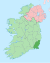
Clongeen (Irish: Cluain Caoin, meaning 'pleasant meadow')[2] is a village and civil parish in County Wexford, Ireland. The village is about 2 kilometres (1.2 mi) south of Foulkesmill. The population was 267 at the 2016 census.[1] The village's Catholic church, St Aidan's (or Edan's), was completed in 1839.[3] Clongeen GAA Club competes in football and camogie.[4]
References
[edit]- ^ a b "Clongeen (Ireland)". City Population. Retrieved 21 January 2022.
- ^ "Cluain Caoin/Clongeen". Placenames Database of Ireland (logainm.ie). Retrieved 21 January 2022.
- ^ "Saint Edan's Catholic Church". National Inventory of Architectural Heritage (NIAH). Retrieved 21 January 2022.
- ^ "Big day for a great club". New Ross Standard. 5 June 2012. Retrieved 21 January 2022 – via Irish Independent.


