Japão-Liberdade (São Paulo Metro)
Appearance
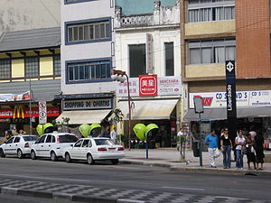
 Square in Liberdade with station marker on right. | ||||||||||||||||||||||||||||||||||||||||||||||||||||||||||||||||||||||
| General information | ||||||||||||||||||||||||||||||||||||||||||||||||||||||||||||||||||||||
| Coordinates | 23°33′17″S 46°38′08″W / 23.554772°S 46.635654°W | |||||||||||||||||||||||||||||||||||||||||||||||||||||||||||||||||||||
| Owned by | ||||||||||||||||||||||||||||||||||||||||||||||||||||||||||||||||||||||
| Operated by | ||||||||||||||||||||||||||||||||||||||||||||||||||||||||||||||||||||||
| Platforms | Side platforms | |||||||||||||||||||||||||||||||||||||||||||||||||||||||||||||||||||||
| Construction | ||||||||||||||||||||||||||||||||||||||||||||||||||||||||||||||||||||||
| Structure type | Underground | |||||||||||||||||||||||||||||||||||||||||||||||||||||||||||||||||||||
| Accessible | Yes | |||||||||||||||||||||||||||||||||||||||||||||||||||||||||||||||||||||
| Other information | ||||||||||||||||||||||||||||||||||||||||||||||||||||||||||||||||||||||
| Station code | LIB | |||||||||||||||||||||||||||||||||||||||||||||||||||||||||||||||||||||
| History | ||||||||||||||||||||||||||||||||||||||||||||||||||||||||||||||||||||||
| Opened | February 17, 1975 | |||||||||||||||||||||||||||||||||||||||||||||||||||||||||||||||||||||
| Previous names | Liberdade | |||||||||||||||||||||||||||||||||||||||||||||||||||||||||||||||||||||
| Passengers | ||||||||||||||||||||||||||||||||||||||||||||||||||||||||||||||||||||||
| 21,000/business day[1] | ||||||||||||||||||||||||||||||||||||||||||||||||||||||||||||||||||||||
| Services | ||||||||||||||||||||||||||||||||||||||||||||||||||||||||||||||||||||||
| ||||||||||||||||||||||||||||||||||||||||||||||||||||||||||||||||||||||
| ||||||||||||||||||||||||||||||||||||||||||||||||||||||||||||||||||||||
Japão–Liberdade (Portuguese: Estação Japão–Liberdade) is a station on Line 1 (Blue) of the São Paulo Metro, serving the Japão section of the Liberdade district. The station opened in 1975 and receives 21,000 passengers per day. Access to the station is via Praça da Liberdade, the center of the historically Japanese-Brazilian neighborhood.[2][3]
References
- ^ "Entrada de Passageiros por Estação - Média Dias Úteis - 2023" (PDF) (in Portuguese). 2023-09-15. Retrieved 2023-09-27.
- ^ "Metrô: Estação Liberdade dá acesso à cultura japonesa em São Paulo" (in Portuguese). Governo do Estado de São Paulo. 2016-06-06. Retrieved 2016-12-14.
- ^ "Liberdade". São Paulo Metro (in Portuguese).
