Si-o-se-pol
Si-o-se-pol | |
|---|---|
 | |
| Coordinates | 32°38′41.53″N 51°40′3.32″E / 32.6448694°N 51.6675889°E |
| Crosses | Zayanderud |
| Locale | Isfahan, Iran |
| Characteristics | |
| Design | Arch bridge, double-deck |
| Material | Stone and brick |
| Total length | 297.76 metres (976.9 ft) |
| Width | 14.75 metres (48.4 ft) |
| Longest span | 5.60 metres (18.4 ft) |
| No. of spans | 33 |
| History | |
| Construction start | 1599 |
| Construction end | 1602 |
| Location | |
 | |
The Allahverdi Khan Bridge (Template:Lang-fa), popularly known as Si-o-se-pol (Template:Lang-fa),[1] is the largest of the eleven historical bridges on the Zayanderud, the largest river of the Iranian Plateau, in Isfahan, Iran.[2]
The bridge was built in the early 17th century to serve as both a bridge and a dam.[3] It is a popular recreational gathering place, and is one of the most famous examples of Iran's Safavid architecture.
History
Si-o-se-pol (meaning the bridge of 33 Persian) was built between 1599 and 1602,[4] under the reign of Abbas I, the fifth Safavid king (shah) of Iran. It was constructed under the supervision of Allahverdi Khan Undiladze, the commander-in-chief of the armies, who was of Georgian origin, and was also named after him.[5][6] The bridge served particularly as a connection between the mansions of the elite, as well as a link to the city's vital Armenian neighborhood of New Julfa.[1]
In years of drought (2000–02 and 2013), the river was dammed upstream to provide water for Yazd province.[6]
-
Panoramic photography of the bridge
Structure
The bridge has a total length of 297.76 metres (976.9 ft) and a total width of 14.75 metres (48.4 ft). It is a vaulted arch bridge consisting of two superimposed rows of 33 arches, from whence its popular name of Si-o-se-pol comes, and is made of stone. The longest span is about 5.60 metres (18.4 ft).[4] The interior of Si-o-se-pol was originally decorated with paintings, which were often described by travelers as erotic.[1]
There is a larger base plank at the start of the bridge, under which the Zayanderud flows, supporting a tea house, which is nowadays abandoned.[citation needed]
Gallery
-
A 17th-century drawing of Si-o-se-pol by Jean Chardin.
-
Benches and tables next to Si-o-se-pol.
-
A view of the arches under Si-o-se-pol.
-
Si-o-se-pol in December 2015.
-
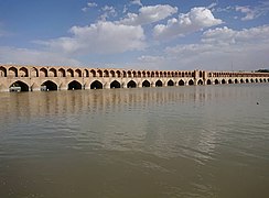
Si-o-se-pol's view of the Zayanderud.
-
The statue of Allahverdi Khan, next to the bridge.
-
Si-o-se-pol at night.
-
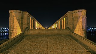
Si-o-se-pol's walkway at night.
-
April 2019
Transportation
 Chaharbagh Street
 Motahari Street
 Kamaloddin Esmaeil Street
 Chahar Bagh Bala Street
 Mellat Street
 Ayenekhaneh Street
 Enqelab Metro Station
 Si-o-se Pol Metro Station
See also
References
- ^ a b c Babaie, Sussan; Haug, Robert (5 April 2012) [15 December 2007]. "Isfahan x. Monuments (5) Bridges". In Yarshater, Ehsan (ed.). Encyclopædia Iranica. 1. Vol. XIV. New York City: Bibliotheca Persica Press. Retrieved 25 September 2015.
- ^ Wagret, Paul (1977). Iran. Geneva: Nagel Publishers. p. 226. ISBN 2-8263-0026-1.
- ^ "Drought poses no threat to Isfahan's Si-o-Se-Pol: official". Tehran Times. 25 December 2017.
- ^ a b "Allahverdi Khan Bridge". Structurae. Retrieved 27 July 2018.
- ^ Savory, Roger (2007). Iran Under the Safavids. Cambridge University Press. p. 170. ISBN 978-0521042512.
- ^ a b Baker, Patricia L.; Smith, Hilary; Oleynik, Maria (2014). Iran. Bradt Travel Guides. ISBN 978-1-84162-402-0.
Further reading
- Poornaderi, Hossein; Qasemi, Jawad; Zand, Roxane (2008). "Allāhwirdī Khān". In Madelung, Wilferd; Daftary, Farhad (eds.). Encyclopaedia Islamica Online. Brill Online. ISSN 1875-9831.


