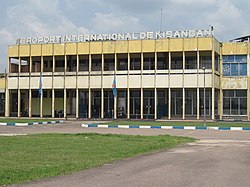
Kisangani Bangoka International Airport
Appearance
Kisangani Bangoka International Airport | |||||||||||
|---|---|---|---|---|---|---|---|---|---|---|---|
 | |||||||||||
| Summary | |||||||||||
| Airport type | Public | ||||||||||
| Serves | Kisangani, Democratic Republic of the Congo | ||||||||||
| Elevation AMSL | 1,417 ft / 432 m | ||||||||||
| Coordinates | 00°28′54″N 025°20′17″E / 0.48167°N 25.33806°E | ||||||||||
| Map | |||||||||||
 | |||||||||||
| Runways | |||||||||||
| |||||||||||
Kisangani Bangoka International Airport (IATA: FKI, ICAO: FZIC) is an airport serving Kisangani, Democratic Republic of the Congo. The airport is 12 kilometres (7.5 mi) east of the city. The Bangoka VOR/DME (Ident: KGI) is 1.7 nautical miles (3.1 km) west of the airport.[3]
Airlines and destinations
| Airlines | Destinations |
|---|---|
| Compagnie Africaine d'Aviation | Bumba,[4] Goma, Kindu, Kinshasa–N'djili |
| Congo Airways | Goma, Kindu, Kinshasa–N'djili |
| Ethiopian Airlines | Addis Ababa[5] |
Accidents and incidents
- On July 8, 2011, Hewa Bora Airways Flight 952, operated by a Boeing 727, crashed on landing. 74 of the 118 on board died.[6]
See also
- Transport in the Democratic Republic of the Congo
- List of airports in the Democratic Republic of the Congo
References
- ^ Airport information for Bangoka International Airport at Great Circle Mapper.
- ^ "Bangoka Airport". Google Maps. Google. Retrieved 19 April 2018.
- ^ "Bangoka VOR-DME (KGI) @ OurAirports". ourairports.com. Retrieved 2018-08-20.
- ^ 2014 March Timetable,http://www.caacongo.com/horaires-20-mars-2014.pdf Archived 2016-03-03 at the Wayback Machine
- ^ Ethiopian changes - RoutesOnline
- ^ Hradecky, Simon (17 August 2011). "Crash: Hewa Bora B721 at Kisangani on Jul 8th 2011, missed runway on landing". The Aviation Herald. Retrieved 16 May 2019.
External links
- Bangoka Airport at OpenStreetMap
- Accident history for Bangoka International Airport at Aviation Safety Network
- Aeronautical chart and airport information for Kisangani Bangoka Airport at SkyVector

