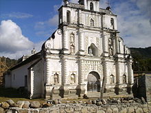
Lempira Department
Lempira Department
Departamento de Lempira | |
|---|---|
 Location of Lempira in Honduras | |
| Coordinates: 14°35′N 88°35′W / 14.583°N 88.583°W | |
| Country | |
| Municipalities | 28 |
| Villages | 303 |
| Founded | 25 June 1825[a] |
| Capital city | Gracias |
| Government | |
| • Type | Departmental |
| • Gobernador | Wilson Rolando Pineda Díaz (2018-2022) (PNH) |
| Area | |
• Total | 4,285 km2 (1,654 sq mi) |
| Population (2015) | |
• Total | 333,125 |
| • Density | 78/km2 (200/sq mi) |
| Time zone | UTC-6 (CDT) |
| Postal code | 42101, 42201 |
| ISO 3166 code | HN-LE |
| HDI (2017) | 0.509[1] low · 18th |
| Statistics derived from Consult INE online database: Population and Housing Census 2013[2] | |

Lempira is one of the 18 departments in Honduras. located in the western part of the country, it is bordered by the departments of Ocotepeque and Copán to the west, Intibucá to the east, and Santa Bárbara to the north. To its south lies the El Salvador–Honduras border. The departmental capital is Gracias.
It was named Gracias department until 1943. In colonial times, Gracias was an early important administrative center for the Spaniards. It eventually lost importance to Antigua, in Guatemala.
Lempira is a rugged department, and it is relatively isolated from the rest of the country. The highest mountain peak in Honduras, Cerro las Minas, is in Lempira. The department was named after Lempira, a local chieftain of the Lenca people who fought against the Spanish conquistadores in the early 16th century. Opals are mined near the town of Erandique.
The department covers a total surface area of 4,290 km². In 2005, had an estimated population of 277,910.
Municipalities
- Belén
- Candelaria
- Cololaca
- Erandique
- Gracias
- Gualcince
- Guarita
- La Campa
- La Iguala
- Las Flores
- La Unión
- La Virtud
- Lepaera
- Mapulaca
- Piraera
- San Andrés
- San Francisco
- San Juan Guarita
- San Manuel Colohete
- San Marcos de Caiquín
- San Rafael
- San Sebastián
- Santa Cruz
- Talgua
- Tambla
- Tomalá
- Valladolid
- Virginia
Notes
- ^ Lempira was one of the first 7 departments in which the national territory was divided in the first political division of Honduras in 1825.
References
- ^ "Sub-national HDI - Area Database - Global Data Lab". hdi.globaldatalab.org. Retrieved 2018-09-13.
- ^ "Consulta Base de datos INE en línea: Censo de Población y Vivienda 2013" [Consult INE online database: Population and Housing Census 2013]. Instituto Nacional de Estadística (INE) (in Spanish). El Instituto Nacional de Estadística (INE). 1 August 2018. Retrieved 2018-09-13.
