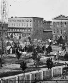
State Square
This is an old revision of this page, as edited by Bender the Bot (talk | contribs) at 12:34, 23 October 2016 (→References: http→https for Google Books and Google News using AWB). The present address (URL) is a permanent link to this revision, which may differ significantly from the current revision.


State Square was the central square of antebellum Atlanta, Georgia. The original Atlanta Union Depot designed by Edward A. Vincent stood in the middle of the square. The square was bounded by Marietta Street (now Decatur Street) on the northeast, Pryor Street on the northwest, Loyd Street (now Central Avenue) on the southeast, and Alabama Street on the south. The square was surrounded by Atlanta's most important buildings including the hotels Atlanta, Trout House, and Washington Hall, the Atlanta Bank, retail stores, and warehouses.
The area is now almost entirely taken up by parking lots and parking garages, with a portion occupied by the Georgia State University College of Education, MARTA rail line, and retail and office space lining the north side of Alabama Street.[1]
References
- ^ Google Maps
- Robert Scott Davis, Civil War Atlanta, p.20
- M. Thomas Inge, High Times and Hard Times, p.86
- Seignious v. Metropolitan Atlanta Rapid Transit Authority and Cotter et al. v. Metropolitan Atlanta Rapid Transit Authority, Georgia caselaw
- ATLhistory.com
33°45′10″N 84°23′20″W / 33.7529138°N 84.388902°W / 33.7529138; -84.388902
This U.S. state of Georgia road or road transport-related article is a stub. You can help Wikipedia by expanding it. |
