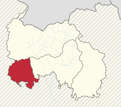
Znaur District
This article needs additional citations for verification. (September 2015) |
Znaur District
ყორნისის რაიონი Знауыры район | |
|---|---|
District | |
 Location of Znaur District in South Ossetia | |
| Coordinates: 42°15′00″N 43°45′00″E / 42.2500°N 43.7500°E | |
| Country | Georgia |
| De facto state | South Ossetia [note 1] |
| Capital | Znauri |
| Government | |
| • Head of administration | Zaur Tskhobrebov |
| • Votes in Parliament | (of 69) |
| Area | |
| • Total | 404 km2 (156 sq mi) |
| Population (1998) | |
| • Total | 9,000 |
| • Density | 22/km2 (58/sq mi) |
| Time zone | UTC+03:00 (MSK) |
Znaur District (Georgian: ყორნისის რაიონი, Qornisis Raioni; Ossetian: Знауыры район, Znauyry rajon; Russian: Знаурский район, Znaurskiy rayon) is one of the districts of South Ossetia. It is located in the southwestern part of South Ossetia. Znauri[1] is the administrative center of the district.
International status
According to administrative division of Georgia, its territory is part of Kareli Municipality of Shida Kartli.
Notes
- ^ South Ossetia's status is disputed. It considers itself to be an independent state, but this is recognised by only a few other countries. The Georgian government and most of the world's other states consider South Ossetia de jure a part of Georgia's territory.
References
