São Jorge, Cape Verde
Appearance
São Jorge | |
|---|---|
Settlement | |
| Coordinates: 15°00′47″N 24°25′48″W / 15.013°N 24.430°W | |
| Country | Cape Verde |
| Island | Fogo |
| Municipality | São Filipe |
| Civil parish | São Lourenço |
| Population (2010)[1] | |
• Total | 635 |
| ID | 82111 |
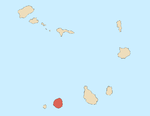
São Jorge is a settlement in the northern part of the island of Fogo, Cape Verde. It is situated near the coast, 2 km west of Campanas Baixo, 2 km northeast of Galinheiro and 15 km northeast of the island capital São Filipe.
Sights


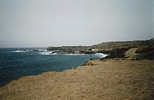
Ponta da Salina is a headland close to the village. There is a small natural harbour and a bay with basalt rock formations, one of which looks like a natural arch. There are some natural swimming pools and a dark sand beach where swimming is possible if the sea is not too rough.[2] There is a sightworthy old cemetery, which is surrounded by a wall, close to the beach.[3] Most of the graves have very simple wooden crosses without any names.
References
- ^ "2010 Census results". Instituto Nacional de Estatística Cabo Verde (in Portuguese). 24 November 2016.
- ^ Reitmaier, Pitt: Cabo Verde, p.391. Bielefeld 2009.
- ^ Lipps, Susanne: Kapverdische Inseln, p.256. Ostfildern 2009.


