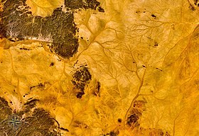
Bayuda Desert


The Bayuda Desert, located at 18°N 33°E / 18°N 33°E, is in the eastern region of the Sahara Desert, spanning approximately 100,000 km² of NE Sudan north of Omdurman and south of Korti, embraced by the great bend of the Nile in the N, E and S and limited by the Wadi Muqaddam in the W. The north to south aligned Wadi Abu Dom divides the Bayuda Desert into the eastern Bayuda Volcanic Field and the western ochre-coloured sand-sheets scattered with rocky outcrop. [1]
Gold mining occurs today from Oct. to March, as labourers work auriferous quartz found in wadis and shallow mines. These workings are usually in areas previously worked during the New Kingdom of Egypt and the Early Arab Period.[2]
The Bayuda Desert route
Throughout the Meroitic civilization the Bayuda Desert became the lifeline connecting the northern and southern districts of the Kingdom of Kush, with Napata and Meroe as the termini. The king Nastasen Stela provides testament of the existence and use of this route, describing his progress across the desert from Meroe to Napata for his coronation. [3]
References
- ^ Description of the Bayuda Desert
- ^ Klemm, Rosemarie; Klemm, Dietrich (2013). Gold and Gold Mining in Ancient Egypt and Nubia. Heidelberg: Springer. pp. 591–599, 619. ISBN 9783642225079.
- ^ Intisar Soghayroun, Elzein Soghayroun: Trade and Wadi Systems in Muslim Sudan, Kampala 2010
