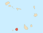
Monte Vermelho, Fogo
Appearance
Monte Vermelho, Fogo | |
|---|---|
Settlement | |
| Coordinates: 14°50′43″N 24°19′41″W / 14.8454°N 24.3281°W | |
| Country | Cape Verde |
| Island | Fogo |
| Municipality | Santa Catarina do Fogo |
| Civil parish | Santa Catarina do Fogo |
| Population (2010)[1] | |
| • Total | 221 |
| ID | 83194 |
Monte Vermelho is a settlement in the southeastern part of the island of Fogo, Cape Verde. It is situated 3 km east of Fonte Aleixo, 3 km southwest of Figueira Pavão, 6 km southwest of Cova Figueira and 19 km southeast of the island capital São Filipe. At the 2010 census its population was 221. Its elevation is about 400 meters.
See also
[edit]References
[edit]- ^ "2010 Census results". Instituto Nacional de Estatística Cabo Verde (in Portuguese). 24 November 2016.


