Waldburg-Wurzach
Appearance
County (Principality) of Waldburg-Wurzach Grafschaft (Fürstentum) Waldburg-Wurzach | |||||||||
|---|---|---|---|---|---|---|---|---|---|
| 1674–1806 | |||||||||
| Status | State of the Holy Roman Empire | ||||||||
| Capital | Wurzach | ||||||||
| Common languages | Alemannic German | ||||||||
| Government | Principality | ||||||||
| Historical era | Middle Ages | ||||||||
| 1674 | |||||||||
• Raised to principality | 1803 | ||||||||
| 1806 | |||||||||
| |||||||||
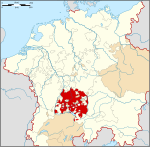
Waldburg-Wurzach was a county ruled by the House of Waldburg, located on the southeastern border of Baden-Württemberg, Germany, located around Wurzach (located about 15 kilometres west of Bad Waldsee). Waldburg-Wurzach was a partition of Waldburg-Zeil. Waldburg-Wurzach was a county prior to 1803, when it was raised to a principality shortly before being mediatised to Württemberg in 1806.
Rulers of Waldburg-Wurzach
Counts of Waldburg-Wurzach (1674–1803)
- Sebastian Wunibald (1674–1700)
- Ernest James (1700–34)
- Francis Ernest (1734–81)
- Eberhard I (1781–1803)
Prince of Waldburg-Wurzach (1803–06)
- Eberhard I (1803–06)
47°55′N 9°46′E / 47.917°N 9.767°E


