Issers
36°42′58″N 3°39′58″E / 36.716°N 3.666°E
Isser | |
|---|---|
Commune and town | |
 | |
| Country | |
| Province | Boumerdès Province |
| Population (1998) | |
| • Total | 27,990 |
| Time zone | UTC+1 (CET) |
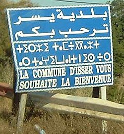
Isser, formerly spelled Issers (Arabic: يسر, Kabyle: ⵉⵙⴻⵔ) is a town and commune in Boumerdès Province, Algeria. According to the 1998 census it has a population of 27,990.[1] As of the latest census it has 32,580 residents.[2]
Isser is located on the south bank of the Isser River and near the centre of the Isser coastal plain, which stretches from Thenia to Naciria.
Transport
The road RN 12 runs through Isser, linking it with Si-Mustapha to the west and Bordj Menaïel to the east. The smaller RN 68 links it to Djinet in the north and Chabet el Ameur in the south.[3]
Notable people
- Messaoud Aït Abderrahmane, footballer
- Sidi Abder Rahman El Thaelebi, Islamic scholar
References
- ^ Statoids
- ^ "ﺗﻮزﻳﻊ اﻟﺴﻜﺎن اﻟﻤﻘﻴﻤﻴﻦ ﻣﻦ اﻷﺳﺮ اﻟﻌﺎدﻳﺔ واﻟﺠﻤﺎﻋﻴﺔ ﺣﺴﺐ ﺑﻠﺪﻳﺔاﻹﻗﺎﻣﺔ واﻟﺘﺸﺘﺖ / Répartition de la population résidente des ménages ordinaires et collectifs, selon la commune de résidence et la dispersion." (Archive) National Office of Statistics. Retrieved on 13 March 2013.
- ^ Atlas Routier de l'Algérie : Wilaya de Boumerdès

