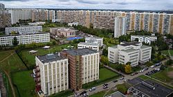
Mitino District
Appearance
Mitino
Митино | |
|---|---|
 Mitino Microdistrict #3, Mitino District | |
 Location of Mitino District on the map of Moscow | |
| Coordinates: 55°50′45″N 37°21′40″E / 55.84583°N 37.36111°E | |
| Country | Russia |
| Federal subject | Moscow |
| Area | |
| • Total | 12.67 km2 (4.89 sq mi) |
| Population | |
| • Estimate (2017)[1] | 183,000 |
| Time zone | UTC+3 (MSK |
| OKTMO ID | 45367000 |
| Website | http://mitino.mos.ru/ |
Mitino District (Russian: райо́н Ми́тино) is an administrative district (raion) of North-Western Administrative Okrug, and one of the 125 raions of Moscow, Russia.[3] It is just outside the Moscow Ring Road, 17 km northwest of the center of Moscow. The area of the district is 12.67 square kilometers (4.89 sq mi). Population: 183,000 (2017 est.)[1];--> (2002 Census); (1989 Soviet census).[4]
History
Located in the outskirts of Moscow, the original village of Mitino merged into the city in 1985.
See also
References
Notes
- ^ a b c "General Information" (in Russian). Mitino District. Retrieved April 12, 2018.
- ^ "Об исчислении времени". Официальный интернет-портал правовой информации (in Russian). 3 June 2011. Retrieved 19 January 2019.
- ^ Государственный комитет Российской Федерации по статистике. Комитет Российской Федерации по стандартизации, метрологии и сертификации. №ОК 019-95 1 января 1997 г. «Общероссийский классификатор объектов административно-территориального деления. Код 45», в ред. изменения №278/2015 от 1 января 2016 г.. (State Statistics Committee of the Russian Federation. Committee of the Russian Federation on Standardization, Metrology, and Certification. #OK 019-95 January 1, 1997 Russian Classification of Objects of Administrative Division (OKATO). Code 45, as amended by the Amendment #278/2015 of January 1, 2016. ).
- ^ Всесоюзная перепись населения 1989 г. Численность наличного населения союзных и автономных республик, автономных областей и округов, краёв, областей, районов, городских поселений и сёл-райцентров [All Union Population Census of 1989: Present Population of Union and Autonomous Republics, Autonomous Oblasts and Okrugs, Krais, Oblasts, Districts, Urban Settlements, and Villages Serving as District Administrative Centers]. Всесоюзная перепись населения 1989 года [All-Union Population Census of 1989] (in Russian). Институт демографии Национального исследовательского университета: Высшая школа экономики [Institute of Demography at the National Research University: Higher School of Economics]. 1989 – via Demoscope Weekly.
Sources
External links
![]() Media related to Mitino at Wikimedia Commons
Media related to Mitino at Wikimedia Commons


