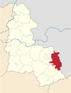
Krasnopillia Raion
Appearance
Krasnopillia Raion
Краснопільський район | |
|---|---|
 Raion location in Sumy Oblast | |
| Coordinates: 50°48′36.0216″N 35°14′20.4144″E / 50.810006000°N 35.239004000°E | |
| Country | |
| Oblast | Sumy Oblast |
| Admin. center | Krasnopillia |
| Area | |
| • Total | 1,350 km2 (520 sq mi) |
| Population (2015) | |
| • Total | 28,598 |
| • Density | 21/km2 (55/sq mi) |
| Time zone | UTC+2 (EET) |
| • Summer (DST) | UTC+3 (EEST) |
| Website | http://krasrada.sumy.ua/ |
Krasnopilskyi Raion (Ukrainian: Краснопільський район) is a raion in Sumy Oblast, Central Ukraine. The administrative center of the raion is the urban-type settlement of Krasnopillia. The population was estimated at 28,598 in 2015.


