Kumbalam, Ernakulam
Kumbalam
കുമ്പളം | |
|---|---|
Town | |
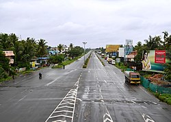
 NH 47 view from Kumbalam | |
| Coordinates: 9°54′N 76°19′E / 9.90°N 76.31°E | |
| State | Kerala |
| District | Ernakulam |
| Government | |
| • Body | Kumbalam Grama Panchayath |
| Elevation | 3 m (10 ft) |
| Population | |
| • Total | 24,143 |
| • Density | 1,161/km2 (3,010/sq mi) |
| Languages | |
| • Official | Malayalam, English |
| Time zone | UTC+5:30 (IST) |
| PIN | 682506 |
| Lok Sabha constituency | Ernakulam |
| Civic agency | Kumbalam Grama Panchayath |
| Climate | Tropical monsoon (Köppen) |
| Avg. summer temperature | 35 °C (95 °F) |
| Avg. winter temperature | 20 °C (68 °F) |
Kumbalam is a picturesque region in Kochi, in the state of Kerala, India. A water-bound countryside, bound by the Vembanad Lake, as well as the fast encroaching city of Kochi, it is situated around 9 km from Vytilla Junction.

Location
Wikimedia Commons has media related to Kumbalam, Ernakulam.


