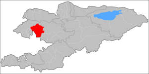
Aksy District
Aksy | |
|---|---|
 | |
 | |
| Country | Kyrgyzstan |
| Region | Jalal-Abad Region |
| Area | |
| • Total | 1,768 sq mi (4,578 km2) |
| Population (2009) | |
| • Total | 113,010 |
| • Density | 64/sq mi (25/km2) |
| Time zone | UTC+5 (GMT +5) |
Aksy is a raion (district) of Jalal-Abad Region in western Kyrgyzstan. The capital lies at Kerben.[1] Its area is 4,578 square kilometres (1,768 sq mi), and its resident population was 113,010 in 2009.[2]
History
Aksy District was established on 29 October 1935 as Jangy-Jol District. In 1962, Ala-Buka District was merged in Jangy-Jol District. In 1969, part of the aiyl okmotu (rural communities) were re-subordinated to newly established Ala-Buka District. On March 6, 1992 Jangy-Jol District was renamed into Aksy District.
Populated places
In total, Aksy District include 1 town and 68 villages in 11 rural communities (aiyl okmotus). Each rural community can consist of one or several villages. The rural communities and settlements in the Aksy District are:[3][2]
- The town of Kerben (including 6 villages: Kurulush, Kuluk-Dobo, Ak-Dobo, Jetigen, Mamay and Ustukan)
- Ak-Jol aiyl okmotu (9: center - village: Ak-Jol; and also villages Jolborstu, Kara-Tyt, Kechuu, Raykomol, Tegene, Kyzyl-Beyit, Kürp and Razan-Say)
- Avletim aiyl okmotu (9: center - village: Avletim; and also villages Baykashka-Terek, Deres-Say, Jangaktuu-Bulak, It-Agar, Korgon, Mukur, Tegermen-Say and Tovar-Say)
- Jany-Jol aiyl okmotu (4: center - village: Jangy-Jol (i.e. nowadays Malkaldy village); and also villages Koy-Tash, Tashtak and Ters)
- Ak-Suu aiyl okmotu (3: center - village: Ak-Suu; and also villages Ak-Say and Korgon-Döbö)
- Kara-Jygach aiyl okmotu (6: center - village: Kara-Jygach; and also villages Dardak-Debe, Kara-Oy, Syny, Torkamysh and Charba)
- Kashka-Suu aiyl okmotu (4: center - village: Kashka-Suu; and also villages Jany-Aiyl, Kara-Döbö and Sogot)
- Mavlyanov aiyl okmotu (7: center - village: Atana; and also villages Munduz, Sary-Kashka, Semet, Toruk, Uluk and Chie)
- Kyzyl-Tuu aiyl okmotu (4: center - village: Kyzyl-Tuu; and also villages Arkit, Jylgyn and Jol-Say)
- Kara-Suu aiyl okmotu (9: center - village: Top-Jangak; and also villages Juzumjan, Kara-Suu, Kezart, Kyzyl-Kel, Say-Bulun, Turdyuk, Chaldybar and Chat)
- Jerge-Tal aiyl okmotu (3: center - village: Jerge-Tal; and also villages Bospiek and Kyzyl-Kapchygay)
- Nazaraliev aiyl okmotu (4: center - village: Kyzyl-Jar; and also villages Jyl-Kol, Kum and Naryn)
Prominent people from the Aksy district
There were several prominent people from the Aksy area of the Jalal-Abad region in Kyrgyzstan.
In the 19th century: prominent statesman Nuzup Mingbashy (Yusuf Mingbashi) of the Kokand khanate, poet Jengijok, etc.
In the 20th century: a poet Temirkul Umetaliev, a writer Tologon Kasymbekov, etc.
At the end of the 20th century - beginning of the 21st century: politicians Topchubek Turgunaliev, Azimbek Beknazarov, a historian Tashmanbet Kenensariev, a journalist Uran Toktonazarovich Botobekov, etc.
References
- ^ Enrin.grida.no Archived 2009-08-02 at the Wayback Machine
- ^ a b "2009 population census of the Kyrgyz Republic: Jalal-Abad Region" (PDF). Archived from the original (PDF) on 10 August 2011. Retrieved 2011-08-10.
- ^ "List of rural communities of Kyrgyzstan". Archived from the original on 2010-02-09. Retrieved 2010-04-14.

