Jump to content

Rame, Wendron

Coordinates: 50°09′44″N 5°11′00″W / 50.1621°N 5.1833°W / 50.1621; -5.1833
From Wikipedia, the free encyclopedia

This is an old revision of this page, as edited by Gazamp (talk | contribs) at 18:10, 3 January 2020 (→‎References: Added Portal:Cornwall). The present address (URL) is a permanent link to this revision, which may differ significantly from the current revision.

Rame
Rame is located in Cornwall
Rame
Rame
Location within Cornwall
OS grid referenceSW727339
Civil parish
Shire county
Region
CountryEngland
Sovereign stateUnited Kingdom
Postcode districtTR10
PoliceDevon and Cornwall
FireCornwall
AmbulanceSouth Western
List of places
UK
England
Cornwall
50°09′44″N 5°11′00″W / 50.1621°N 5.1833°W / 50.1621; -5.1833

Rame (Cornish: Hordh) is a small village approximately three miles west of Penryn and five miles northeast of Helston in Cornwall, England, UK. It is located on the A394 main road.[1]

The tenement of Rame has for generations been in the possession of the Williams family of Scorrier.[2]
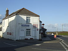
Rame Post Office and general store

References

  1. ^ Ordnance Survey One-inch Map of Great Britain; Truro and Falmouth, sheet 190. 1961
  2. ^ Langdon, A. G. (1896) Old Cornish Crosses. Truro: Joseph Pollard; p. 333