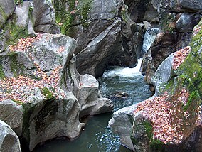
Sculptured Rocks Natural Area
This is an old revision of this page, as edited by Ser Amantio di Nicolao (talk | contribs) at 05:17, 7 January 2020 (→External links: add authority control). The present address (URL) is a permanent link to this revision, which may differ significantly from the current revision.
| Sculptured Rocks Natural Area | |
|---|---|
 Sculptured Rocks on the Cockermouth River | |
| Location | Grafton, New Hampshire, United States |
| Coordinates | 43°42′26″N 71°51′16″W / 43.70722°N 71.85444°W / 43.70722; -71.85444 |
| Area | 272 acres (110 ha) |
| Governing body | New Hampshire Parks and Recreation |
| Website | Sculptured Rocks Natural Area |
The Sculptured Rocks Natural area is a 272-acre (110 ha) natural area in Groton, New Hampshire. Its main feature is its namesake, the Sculptured Rocks, which are a series of narrow, sharply carved rock formations that are a popular local swimming hole. They are located on the Cockermouth River, which is the longest tributary of Newfound Lake. The Sculptured Rocks Road, which runs along this same river, shares its namesake with the park.
References
External links
- Sculptured Rocks Natural Area NH Division of Parks and Recreation
| Tributaries |
| ||||
|---|---|---|---|---|---|
| Lakes |
| ||||
| Towns |
| ||||
| Landmarks |
| ||||
This New Hampshire state location article is a stub. You can help Wikipedia by expanding it. |
