Arrien-en-Bethmale
Arrien-en-Bethmale | |
|---|---|
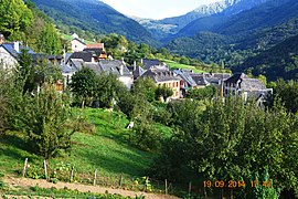
 A general view of Arrien-en-Bethmale | |
| Coordinates: 42°53′51″N 1°02′32″E / 42.8975°N 1.0422°E | |
| Country | France |
| Region | Occitania |
| Department | Ariège |
| Arrondissement | Saint-Girons |
| Canton | Couserans Ouest |
| Intercommunality | CC Couserans - Pyrénées |
| Government | |
| • Mayor (2014-2020) | Gérard Pons |
| Area 1 | 14.59 km2 (5.63 sq mi) |
| Population (2021)[1] | 112 |
| • Density | 7.7/km2 (20/sq mi) |
| Time zone | UTC+01:00 (CET) |
| • Summer (DST) | UTC+02:00 (CEST) |
| INSEE/Postal code | 09017 /09800 |
| Elevation | 598–2,085 m (1,962–6,841 ft) (avg. 620 m or 2,030 ft) |
| 1 French Land Register data, which excludes lakes, ponds, glaciers > 1 km2 (0.386 sq mi or 247 acres) and river estuaries. | |
Arrien-en-Bethmale is a commune in the Ariège department in the Occitanie region of south-western France.
The inhabitants of the commune are known as Arrienois or Arrienoises[2]
Geography
Arrien-en-Bethmale consists of the villages of Aret, Arrian, Tournac, and Villargein, all located in the Pyrenees mountains in the Bethmale valley in the former province of Couserans some 12 km south-west of Saint-Girons and 3 km south of Castillon-en-Couserans. It is part of the Regional Natural Park of Pyrenees Ariège. Access to the commune is by the D17 road from Les Bordes-sur-Lez in the north-west passing through the commune and the village and continuing south-east to Bethmale. The commune is a rugged alpine commune heavily forested in many parts.[3]
The Ruisseau de Cournelliere and the De Leaude rise north-east of the village and flow down to the south-west to join the Balamet river which flows down the valley to join the Lez north-west of the commune just south of Les Bordes-sur-Lez. The Ruisseau de Mourtis flows through the south of the commune also into the Lez.[3]
Neighbouring communes and villages[3]
History
The commune was created on 18 February 1931 when it separated from the current commune of Bethmale.
Arrien-en-Bethmale has a very ancient history, as evidenced by the discovery of a funerary inscription dating probably from the 1st century.
Administration
List of Successive Mayors[4]
| From | To | Name | Party | Position |
|---|---|---|---|---|
| 2001 | 2008 | Robert Soubie | ||
| 2008 | 2020 | Gérard Pons |
(Not all data is known)
Demography
In 2010 the commune had 101 inhabitants. The evolution of the number of inhabitants is known from the population censuses conducted in the commune since 1931. From the 21st century, a census of communes with fewer than 10,000 inhabitants is held every five years, unlike larger towns that have a sample survey every year.[Note 1]
Template:Table Population Town


Culture and heritage
Religious heritage
The Church contains several items that are registered as historical objects:
- An Altar, Retable, Tabernacle, 3 Statues, and a Painting (18th century)
 [5]
[5] - 2 Candlesticks (18th century)
 [6]
[6] - An Altar, Retable, Tabernacle, 2 Paintings, and 2 Bas-Reliefs (18th century)
 [7]
[7] - An Altar, Retable, Tabernacle, 3 Statues, and a Painting (18th century)
 [8]
[8]
Notable people linked to the commune
- Roman Caramalli as monk for the Parish from 1999 to 2005 contributed to the recognition of the commune by promoting local culture.
See also
External links
- Arrien-en-Bethmale on the National Geographic Institute website (in French)
- Arrien-en-Bethmale on Lion1906
- Arrien-en-Bethmale on Google Maps
- Arrien-en-Bethmale on Géoportail, National Geographic Institute (IGN) website (in French)
- Arrieu on the 1750 Cassini Map
- Arrien-en-Bethmale on the INSEE website (in French)
- INSEE (in French)
Notes and references
Notes
- ^ At the beginning of the 21st century, the methods of identification have been modified by Law No. 2002-276 of 27 February 2002 Archived 6 March 2016 at the Wayback Machine, the so-called "law of local democracy" and in particular Title V "census operations" allows, after a transitional period running from 2004 to 2008, the annual publication of the legal population of the different French administrative districts. For communes with a population greater than 10,000 inhabitants, a sample survey is conducted annually, the entire territory of these communes is taken into account at the end of the period of five years. The first "legal population" after 1999 under this new law came into force on 1 January 2009 and was based on the census of 2006.
References
- ^ "Populations légales 2021". The National Institute of Statistics and Economic Studies. 28 December 2023.
- ^ Inhabitants of Ariège (in French)
- ^ a b c Google Maps
- ^ List of Mayors of France (in French)
- ^ Ministry of Culture, Palissy PM09000032 Altar, Retable, Tabernacle, 3 Statues, and a Painting (in French)

- ^ Ministry of Culture, Palissy PM09000031 2 Candlesticks (in French)

- ^ Ministry of Culture, Palissy PM09000030 Altar, Retable, Tabernacle, 2 Paintings, and 2 Bas-Reliefs (in French)

- ^ Ministry of Culture, Palissy PM09000029 Altar, Retable, Tabernacle, 3 Statues, and a Painting (in French)


