Punggol Park
Appearance
| Punggol Park | |
|---|---|
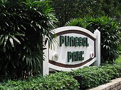
 Stone sign at Punggol Park | |
| Type | Neighbourhood park |
| Location | Hougang, Singapore |
| Coordinates | 1°22′38″N 103°53′50″E / 1.3771523°N 103.897315°E |
| Area | 16 hectares |
| Operated by | National Parks Board |
| Status | Open |
| Website | www |
Punggol Park (Chinese: 榜鹅公园) is a park located in Hougang, in the north-eastern part of Singapore. The park is 16 hectares in size, with a 5 ha lake. Kite flying is not allowed here due to the proximity of Paya Lebar Air Base.
The park has two distinctive zones: the "Southern Active Zone" where the features for major activities are provided, and the densely forested area in the north of the lake which forms the "Passive Zone".[1]
The plan for a park at Hougang was announced in November 1992. The park was named Punggol Park and the junction of Hougang Avenue 8 and Hougang Avenue 10 was chosen as the location.

For the park at Punggol Point please see Punggol Point Park
See also
References
- ^ "Punggol Park". National Parks Board. Retrieved 10 June 2016.
External links
- Punggol Park at National Parks Board
