
Eagle, Pennsylvania
Eagle, Pennsylvania | |
|---|---|
 Intersection of Pottstown Pike and Little Conestoga Road in Eagle | |
 Eagle Location of Eagle in Pennsylvania  Eagle Eagle (the United States) | |
| Coordinates: 40°04′38″N 75°41′15″W / 40.07722°N 75.68750°W | |
| Country | United States |
| State | Pennsylvania |
| County | Chester |
| Township | Upper Uwchlan |
| Elevation | 256 ft (78 m) |
| Population (2000) | |
| • Total | 7,520 |
| Time zone | UTC-5 (EST) |
| • Summer (DST) | UTC-4 (EDT) |
| Area code | 610 |
Eagle (also "Uwchland", "Windsor" or the "Village of Eagle") is an unincorporated community in Upper Uwchlan Township, Chester County, Pennsylvania, United States. Located at 40°4′40″N 75°41′16″W / 40.07778°N 75.68778°W,[1] the center of the village is the intersection of Pottstown Pike (Pennsylvania Route 100) and Little Conestoga Road, where the historic Eagle Tavern is located. Eagle has recently experienced tremendous development, including upgrades to the village's main roads.[citation needed]
Gallery
-
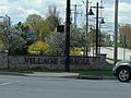 Welcome sign for Village of Eagle, at the corner of Station Blvd./Park Rd. and Route 100
 -
 Eagle Tavern at Little Conestoga Rd. and Route 100


References
External links
Wikimedia Commons has media related to Eagle, Pennsylvania.
