Cenadi
This article needs additional citations for verification. (November 2015) |
Cenadi | |
|---|---|
| Comune di Cenadi | |
| Coordinates: 38°43′N 16°25′E / 38.717°N 16.417°E | |
| Country | Italy |
| Region | Calabria |
| Province | Catanzaro (CZ) |
| Frazioni | Cortale, Olivadi, Polia (VV), San Vito sullo Ionio, Vallefiorita |
| Area | |
| • Total | 11 km2 (4 sq mi) |
| Elevation | 539 m (1,768 ft) |
| Population (31 December 2013)[2] | |
| • Total | 573 |
| • Density | 52/km2 (130/sq mi) |
| Demonym | Cenadesi |
| Time zone | UTC+1 (CET) |
| • Summer (DST) | UTC+2 (CEST) |
| Postal code | 88067 |
| Dialing code | 0967 |
| ISTAT code | 079024 |
| Patron saint | San Giovanni Battista |
| Saint day | 24 June |
| Website | Official website |
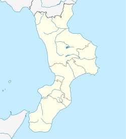
Cenadi (Greek: Genadioi) is a comune and town in the province of Catanzaro in the Calabria region of Italy.
Etymology
The town's name is derived from cena, the Italian word for "dinner". A legend claims that St. John the Evangelist was passing through the town on his way to Rome, and stopped for dinner.[citation needed]
References
- ^ "Superficie di Comuni Province e Regioni italiane al 9 ottobre 2011". Italian National Institute of Statistics. Retrieved 16 March 2019.
- ^ All demographics and other statistics from the Italian statistical institute (Istat)


