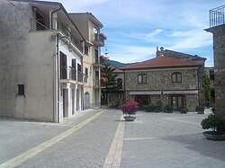
Sicilì
Sicilì | |
|---|---|
 A village's square | |
| Coordinates: 40°08′11.3″N 15°31′50.0″E / 40.136472°N 15.530556°E | |
| Country | Italy |
| Region | |
| Province | Salerno (SA) |
| Comune | Morigerati |
| Elevation | 205 m (673 ft) |
| Population (2011)[1] | |
| • Total | 364 |
| Demonym | Siciliesi |
| Time zone | UTC+1 (CET) |
| • Summer (DST) | UTC+2 (CEST) |
| Postal code | 84030[2] |
| Dialing code | (+39) 0974 |
| Patron saint | St. Blaise[3] |
| Saint day | 3 February and 14 May[3] |
Sicilì is a southern Italian village and hamlet (frazione) of Morigerati, a municipality in the province of Salerno, Campania. As of 2011, it had a population of 364.[1]
History
The village was first mentioned in 1521. It was named after Sicily, in honor of a Sicilian farmer who used the surrounding rural areas for pastoralism.[4]
Geography
Sicilì is a hill village located in southern Cilento, next to the Bussento river and its caves, a WWF oasis.[5][6] It is 3 km from Morigerati, 8 from Caselle in Pittari and Santa Marina, 13 from Torre Orsaia, 14 from Castel Ruggero, and 14 from Policastro, by the Tyrrhenian Coast.[7]
Transport
The village is served by the national highway SS 517/var Padula-Policastro at the exit "Sicilì-Morigerati", 3 km west. The highway links the Cilentan highway to the A3 Motorway. Nearest railway station, Torre Orsaia, is 17 km southwest.
See also
References
- ^ a b (in Italian) Info on italia.indettaglio.it
- ^ (in Italian) Sicilì on tuttocitta.it
- ^ a b (in Italian) Info on sanbiagiosicili.it
- ^ (in Italian) Historical info about Sicilì
- ^ (in Italian) Bussento Caves (WWF.it website)
- ^ (in Italian) WWF Oasis of Bussento on Morigerati website
- ^ 1096926072 Sicilì on OpenStreetMap
External links
![]() Media related to Sicilì at Wikimedia Commons
Media related to Sicilì at Wikimedia Commons
- (in Italian) Sicilì and Saint Blaise website

