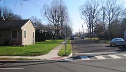
Slackwood, New Jersey
Slackwood, New Jersey | |
|---|---|
 Looking down Harmony Avenue from Princeton Pike (CR 583) | |
| Coordinates: 40°15′11″N 74°44′05″W / 40.25306°N 74.73472°W | |
| Country | |
| State | |
| County | Mercer |
| Township | Lawrence |
| Named for | Joseph Slack, William Wood |
| Elevation | 89 ft (27 m) |
| GNIS feature ID | 880639[1] |
Slackwood is an unincorporated community located within Lawrence Township in Mercer County, New Jersey, United States.[2] The area is named for the owners of the land that was subdivided into the neighborhood today, Joseph Slack and William Wood. The neighborhood was first developed in 1890 as the first suburban development in the reconfigured Lawrence Township (a portion of the township had seceded in the 1880s to form Millham Township, now part of the City of Trenton). Its location between Princeton Pike (now County Route 583) and Brunswick Pike (U.S. Route 1 Business) allowed for an easy walk to nearby Trenton factories.[3][4] Today, most of the homes in Slackwood are still small bungalows with some businesses along Princeton and Brunswick Pikes. The neighborhood is bounded by the two highways on the northwest and southeast, Slackwood Park and forest on the southwest, and Shabakunk Creek and Park on the northeast.[5]
References
- ^ a b "Slackwood". Geographic Names Information System. United States Geological Survey, United States Department of the Interior.
- ^ Locality Search, State of New Jersey. Accessed January 9, 2015.
- ^ Kahn, Lee (October 29, 2014). "LAWRENCE: Trolleys played key role in township's past". The Lawrence Ledger. Retrieved December 16, 2015.
- ^ "How Lawrence Township Became a Suburb" (PDF). Lawrence Historical Society. Retrieved December 16, 2015.
- ^ Google (December 16, 2015). "Aerial view of Slackwood" (Map). Google Maps. Google. Retrieved December 16, 2015.


