Wister, Philadelphia
Appearance
Wister | |
|---|---|
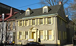
 Clarkson Watson House in Wister, March 2010 | |
| Coordinates: 40°02′10″N 75°09′40″W / 40.036°N 75.161°W | |
| Country | United States |
| State | Pennsylvania |
| County | Philadelphia County |
| City | Philadelphia |
| Area code(s) | 215, 267, and 445 |
Wister is a neighborhood in Northwest Philadelphia, Pennsylvania, United States. It is bounded by Chelten Avenue to the north, Germantown Avenue to the west, Belfield Avenue to the east, and Wister Street to the south.[1][2] Wister is a section within Germantown. The Clarkson-Watson House, Fisher's Lane, Grumblethorpe, Grumblethorpe Tenant House, and Ivy Lodge are listed on the National Register of Historic Places.[3]
References
- ^ "Philadelphia Neighborhoods and Place Names, Q-Z". Philadelphia Information Locator System (PhILS).
- ^ "Wister Neighborhood Council, Inc". Wister Neighborhood Council.
- ^ "National Register Information System". National Register of Historic Places. National Park Service. July 9, 2010.

