
Kucura
Kucura
| |
|---|---|
 | |
 Kucura | |
| Coordinates: 45°31′N 19°35′E / 45.517°N 19.583°E | |
| Country | |
| Province | |
| Municipality | Vrbas |
| Population (2002) | |
| • Total | 4,663 |
| Time zone | UTC+1 (CET) |
| • Summer (DST) | UTC+2 (CEST) |
Kucura (Serbian Cyrillic: Куцура, Rusyn: Коцур) is a village in Serbia, in the Autonomous Province of Vojvodina. It is located in the municipality of Vrbas, in the South Bačka District. The village is ethnically mixed and its population numbering 4,663 people (2002 census).
Ethnic groups
1971
According to the 1971 census, ethnic Rusyns comprised 60% of population of the village.
2002
According to the 2002 census, the population of the village include:
- 2,200 (47.18%) Rusyns
- 1,808 (38.77%) Serbs
- 352 (7.55%) Hungarians
- others.
Historical population
- 1961: 4,881
- 1971: 4,655
- 1981: 4,687
- 1991: 4,713
Notable residents
Gallery
-
 The Uniate church.
 -
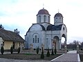 The Orthodox church.
 -
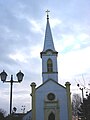 All Saints Catholic Church.


See also
References
- Slobodan Ćurčić, Broj stanovnika Vojvodine, Novi Sad, 1996.
External links
Wikimedia Commons has media related to Kucura.
45°31′N 19°35′E / 45.517°N 19.583°E
This South Bačka District, Vojvodina location article is a stub. You can help Wikipedia by expanding it. |