
Churchtown, Pennsylvania
Churchtown | |
|---|---|
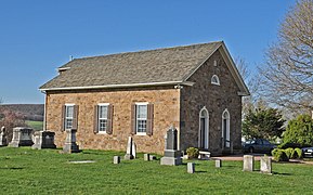
 Bangor Episcopal Church | |
 Churchtown Location within the U.S. state of Pennsylvania | |
| Coordinates: 40°7′59″N 75°57′53″W / 40.13306°N 75.96472°W | |
| Country | United States |
| State | Pennsylvania |
| County | Lancaster |
| Elevation | 564 ft (172 m) |
| Population (2010) | |
| • Total | 470 |
| Time zone | UTC-5 (Eastern (EST)) |
| • Summer (DST) | UTC-4 (EDT) |
| ZIP code | 17555 |
| Area code | 717 |
| GNIS feature ID | 1171873[1] |
Churchtown, Pennsylvania is an unincorporated community and census-designated place located in Caernarvon Township in Lancaster County, Pennsylvania. Churchtown is located along Pennsylvania Route 23. The population was 470 residents as of the 2010 census.
The Bangor Episcopal Church, Caernarvon Presbyterian Church and Edward Davies House are listed on the National Register of Historic Places.[2]
The first settlers of the oldest Amish settlement still in existence, the Lancaster Amish settlement, settled near Churchtown.[3]
-
 Caernarvon Presbyterian Church
 -
 Edward Davies House


