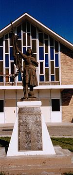
Domremy, Saskatchewan
Appearance
Domremy | |
|---|---|
| Special Service Area of Domremy | |
| Coordinates: 52°47′00″N 105°44′00″W / 52.78333°N 105.73333°W | |
| Country | Canada |
| Province | Saskatchewan |
| Rural Municipalities (R.M.) | St. Louis No. 431 |
| Post office founded (NWT) | 1896-05-01 |
| Area | |
| • Total | 0.75 km2 (0.29 sq mi) |
| Population (2006) | |
| • Total | 124 |
| • Density | 166.3/km2 (431/sq mi) |
| • Summer (DST) | CST |
| [1][2][3][4] | |

Domremy, Saskatchewan (/ˈdɔːrəmi/ DOR-ə-mee)[5] is a special service area[6] in the Rural Municipality of St. Louis No. 431, in the Canadian province of Saskatchewan. It held village status prior to December 31, 2006.[7] The population was 124 people in 2006. Domremy is located on Highway 320 near Highway 2 and Highway 225 in central Saskatchewan. Domremy had a post office established as early as May 1, 1896 in the District of Saskatchewan, NWT.
Domremy is named after the French village of Domrémy the birthplace of Joan of Arc.
Demographics
Canada census – Domremy, Saskatchewan community profile
| 2011 | |
|---|---|
| Population | 125 (+.08% from 2006) |
| Land area | 0.75 km2 (0.29 sq mi) |
| Population density | 167.7/km2 (434/sq mi) |
| Median age | 40.2 (M: 42.5, F: 35.5) |
| Private dwellings | 67 (total) |
| Median household income |
Area statistics
- Lat (DMS) 52° 47' 00" N
- Long (DMS)105° 44' 00" W
- Dominion Land Survey SE Sec.17, Twp.44, R.26, W2
- Time zone (cst) UTC−6
Notable residents
- Stan Hovdebo (1979–1993)
Further reading
Title: Harvest of memories, 1895-1995 Domremy, Sask. : Domremy Historical Society, 1995 vi, 710 p. : ill. ; 29 cm
See also
References
- ^ National Archives, Archivia Net. "Post Offices and Postmasters". Archived from the original on 6 October 2006. Retrieved 30 September 2013.
- ^ Government of Saskatchewan, MRD Home. "Municipal Directory System (R.M. St. Louis No. 431)". Archived from the original on 15 January 2016. Retrieved 30 September 2013.
- ^ Canadian Textiles Institute. (2005), CTI Determine your provincial constituency, archived from the original on 2007-09-11
- ^ Commissioner of Canada Elections, Chief Electoral Officer of Canada (2005), Elections Canada On-line, archived from the original on 2007-04-21
- ^ The Canadian Press (2017), The Canadian Press Stylebook (18th ed.), Toronto: The Canadian Press
- ^ "Municipal Directory System" (PDF). Government of Saskatchewan. p. 226. Retrieved November 19, 2016.
- ^ "Restructured Villages". Saskatchewan Ministry of Municipal Affairs. Archived from the original on March 25, 2008. Retrieved 2008-02-10.
- ^ "2011 Community Profiles". 2011 Canadian Census. Statistics Canada. March 21, 2019. Retrieved 2013-01-09.
- ^ "2006 Community Profiles". 2006 Canadian Census. Statistics Canada. August 20, 2019.
- ^ "2001 Community Profiles". 2001 Canadian Census. Statistics Canada. July 18, 2021.
External links


