Antimilos
Native name: Αντίμηλος | |
|---|---|
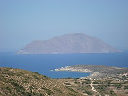
 View from Milos in August 2014. | |
| Geography | |
| Coordinates | 36°47′13″N 24°14′19″E / 36.78694°N 24.23861°E |
| Archipelago | Cyclades |
| Highest elevation | 671 m (2201 ft) |
| Administration | |
Greece | |
| Region | South Aegean |
| Regional unit | Milos |
| Demographics | |
| Population | 0 (2001) |
Antimilos (Template:Lang-el) is a Greek island in the Cyclades, 13 miles (21 kilometres) northwest of Milos. Administratively, it is part of the municipality of Milos. Antimilos is an uninhabited mass of trachyte (671 m height), often called Erimomilos (Desert Milos). It is a volcanic island and the crater is still obvious. Ancient inhabitants transformed the crater to an open rain tank. On the island lives a rare variation of the common goat called Capra aegagrus pictus. It is similar but not the same as the Cretan goat known as "kri-kri" (Capra aegagrus creticus).
History
According to an interpretation of Homer's Odyssey, it is the island of the sun god Helios, where Odysseus's companions slaughtered the sacred cattle of the sun god. Previously, the island was also known by the name Ephyra (Template:Lang-grc)[1] or Ephora (Έφορα, meaning "watchtower"), because one could observe the sea from its highest point over long distances.
Settlement in prehistoric times can be assumed due to remains of walls and arrowheads made of obsidian found on the island. Remains of a cistern probably of Roman or early Christian origin have also been found.
References
- ^
 Smith, William, ed. (1854–1857). "Ephyra". Dictionary of Greek and Roman Geography. London: John Murray.
External links
- Official website of Municipality of Mílos (in Greek and English)


