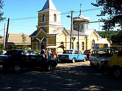
Tarutyne
Tarutyne
Тарутине Тарутино (in Russian) | |
|---|---|
 | |
| Lua error in Module:Location_map at line 526: Unable to find the specified location map definition: "Module:Location map/data/Ukraine Odessa Oblast" does not exist. | |
| Coordinates: 46°11′N 29°9′E / 46.183°N 29.150°E | |
| Country | |
| Oblast | |
| District | Tarutyne Raion |
| Founded | 1812 |
| Area | |
| • Total | 3.99 km2 (1.54 sq mi) |
| Time zone | UTC+2 (EET) |
| • Summer (DST) | UTC+3 (EEST) |
| Postal code | 68500 |
| Area code | +380-4847 |
Tarutyne (Ukrainian: Тарутине; Bulgarian: Тарутино, Tarutino; Romanian: Tarutino, Ancecrac; Greek: Thyratyna) is an urban-type settlement in southwestern Ukraine. It is the seat of Tarutyne Raion (district) of Odessa Oblast and is in the historical region of Budjak in southern Bessarabia. Population: 6,037 (2015 est.)[1]
History
Historical affiliations
Russian Empire 1814–1917
Moldavian Democratic Republic 1917–1918
Kingdom of Romania 1918–1940
Soviet Union 1940–1941
Kingdom of Romania 1941–1944
Soviet Union 1944–1991
Ukraine 1991–present
References
- ^ "Чисельність наявного населення України (Actual population of Ukraine)" (PDF) (in Ukrainian). State Statistics Service of Ukraine. Retrieved 1 July 2016.
