Chenaran County
Appearance
Chenaran County
شهرستان چناران | |
|---|---|
 Razavi Khorasan counties | |
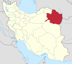
 Location of Razavi Khorasan Province in Iran | |
| Coordinates: 36°40′N 59°09′E / 36.667°N 59.150°E | |
| Country | |
| Province | Razavi Khorasan Province |
| Capital | Chenaran |
| Bakhsh (Districts) | Central District, Golbahar District |
| Population (2016)[1] | |
| • Total | 155,013 |
| Time zone | UTC+3:30 (IRST) |
| • Summer (DST) | UTC+4:30 (IRDT) |
| Chenaran County at GEOnet Names Server | |
Chenaran County (Persian: شهرستان چناران) is a county in Razavi Khorasan Province in Iran. At the 2006 census, its population was 108,533, in 26,937 families.[2] The capital of the county is Chenaran. This city is about 45 km west of Mashhad city. It is an agricultural city with a population of about 30–35 thousand. It has been recently developing industries as well, especially in the industrial area of the city which is in the south. The common sport of the city is wrestling. There are many farms in the outskirts of the city.
Chenaran County has two districts: Central District and Golbajar District. Chenaran County has three cities Chenaran, Shahr Jadid-e Golbahar & Golmakan
References
- ^ "Census of the Islamic Republic of Iran, 1395 (2016)" (Excel). Islamic Republic of Iran.
- ^ "Census of the Islamic Republic of Iran, 1385 (2006)" (Excel). Statistical Center of Iran. Archived from the original on 2011-09-20.
- اطلس گیتاشناسی استانهای ایران [Atlas Gitashenasi Ostanhai Iran] (Gitashenasi Province Atlas of Iran)
External links
Wikimedia Commons has media related to Chenaran County.

