
Wapsipinicon River
| Wapsipinicon River Wapsie River, Wabespinicon River, Wapsiepinnecon River | |
|---|---|
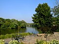
 Wapsipinicon River in Independence, Iowa (Buchanan County) | |
 Wapsipinicon River highlighted | |
| Location | |
| Country | US |
| State | Iowa and Minnesota |
| District | Scott County, Iowa, Clinton County, Iowa, Cedar County, Iowa, Jones County, Iowa, Linn County, Iowa, Buchanan County, Iowa, Black Hawk County, Iowa, Bremer County, Iowa, Chickasaw County, Iowa, Howard County, Iowa, Mitchell County, Iowa, Mower County, Minnesota |
| Physical characteristics | |
| Source | |
| • location | 3/4 mile south of Taopi, Minnesota[1] |
| • coordinates | 43°32′55″N 92°38′40″W / 43.54861°N 92.64444°W[2] |
| • elevation | 1,348 ft (411 m)[1] |
| Mouth | Mississippi River |
• coordinates | 41°43′47″N 90°19′11″W / 41.72972°N 90.31972°W[2] |
• elevation | 574 ft (175 m)[2] |
| Length | 299.5 mi (482.0 km) |
| Discharge | |
| • location | De Witt, Iowa |
| • average | 1,818 cu/ft. per sec.[3] |
The Wapsipinicon River (/wɒpsɪˈpɪnɪkɒn, -kən/,[4] locally known as the Wapsi) is a tributary of the Mississippi River, approximately 300 miles (480 km) long,[5] in southeastern Minnesota and northeastern Iowa in the United States. It drains a rural farming region of rolling hills and bluffs north of Waterloo and Cedar Rapids.
It rises in Mower County, Minnesota and enters Iowa in northern Mitchell County. It flows generally southeast across rural Chickasaw, Bremer, and Buchanan counties, past Independence and Anamosa. Along its lower 25 miles (40 km) it turns east, forming the boundary between Clinton and Scott counties. It joins the Mississippi from the west approximately 10 miles (16 km) southwest of Clinton.
It defines the western boundary of the Driftless Area. While the Wapsi has a soft, recent catchment, the Driftless, to the east and north, tumbles down to the Mississippi in rugged canyons.
The name of the river in the Ojibwe language is Waabizipinikaan-ziibi ("river abundant in swan-potatoes"), on account of the large quantity of arrowheads or wild artichokes, known as "swan-potatoes" (waabizipiniin, singular waabizipin), once found near its banks.[6] Severe flooding on the river in 1993, as part of the larger floods in region, caused widespread damage to the surrounding cropland.
The Wapsipinicon River runs alongside the Iowa cities and communities of McIntire, Riceville, Deerfield, Frederika, Tripoli, Littleton, Otterville, Independence, Quasqueton, Troy Mills, Paris, Central City, Waubeek, Stone City, Anamosa, Olin, Oxford Junction, Oxford Mills, Massillon, Toronto, Wheatland, McCausland, Folletts, and Shaffton before emptying into the Mississippi River. Cedar Rock State Park is located on the Wapsipinicon near Quasqueton. Wapsipinicon State Park is located along its southern bank at Anamosa. Many regional parks also border the river.
The Wapsipinicon is known for excellent fishing for catfish, although it also contains abundant northern pike, carp, sunfish, and walleye (in some areas).
-
 Wapsipinicon River in Independence, Buchanan County, Iowa
 -
 Wapsipinicon River in Buchanan County, Iowa

See also
References
- ^ a b Adams, MN, 7.5 Minute Topographic Quadrangle, USGS, 1965 (1978 rev.)
- ^ a b c U.S. Geological Survey Geographic Names Information System: Wapsipinicon River
- ^ https://waterdata.usgs.gov/ia/nwis/uv/?site_no=05422000&PARAmeter_cd=00065,00060
- ^ https://www.iowapublicradio.org/post/pronouncing-iowa-place-names-audio-guide-expanded-100-entries#stream/0
- ^ U.S. Geological Survey. National Hydrography Dataset high-resolution flowline data. The National Map, accessed May 13, 2011
- ^ Freelang Ojibwe Dictionary
External links
- Rivers of Iowa
- Rivers of Minnesota
- Tributaries of the Mississippi River
- Bodies of water of Scott County, Iowa
- Bodies of water of Clinton County, Iowa
- Bodies of water of Cedar County, Iowa
- Bodies of water of Jones County, Iowa
- Bodies of water of Linn County, Iowa
- Bodies of water of Buchanan County, Iowa
- Bodies of water of Black Hawk County, Iowa
- Bodies of water of Bremer County, Iowa
- Bodies of water of Chickasaw County, Iowa
- Bodies of water of Howard County, Iowa
- Bodies of water of Mitchell County, Iowa
- Rivers of Mower County, Minnesota