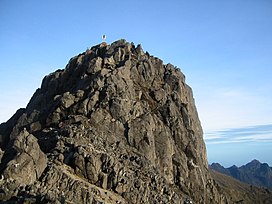
Bismarck Range
Appearance
| Bismarck Range | |
|---|---|
 Mount Wilhelm in the Bismarck Range | |
| Highest point | |
| Peak | Mount Wilhelm |
| Elevation | 4,509 m (14,793 ft) |
| Coordinates | 5°48′S 145°02′E / 5.800°S 145.033°E |
| Geography | |
| Country | Papua New Guinea |
| Provinces | Simbu, Madang and Western Highlands |
| Range coordinates | 5°30′S 144°45′E / 5.500°S 144.750°E |
The Bismarck Range is a mountain range in the Western Highlands Province of Papua New Guinea.[1][2] The range is named after the German Chancellor, Otto von Bismarck. From the 1880s to 1914 this part of the island was a German colony.
The highest point is Mount Wilhelm at 4,509 m (14,793 ft). At over 3,400 metres (11,155 ft), the landscape is alpine with tundra, in spite of the tropical climate. The Ramu River has its source in the range.

References
- ^ Bismarck Range: Papua New Guinea National Geospatial-Intelligence Agency, Bethesda, MD, USA
- ^ Bismarck Range

