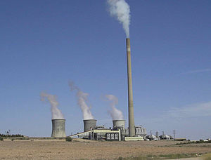
Teruel Power Plant
| Teruel Power Plant | |
|---|---|
 | |
 | |
| Official name | Central térmica de Andorra |
| Country | Spain |
| Location | Andorra, Teruel |
| Coordinates | 40°59′50.84″N 0°22′52.23″W / 40.9974556°N 0.3811750°W |
| Status | Decommissioned |
| Commission date | 1981 |
| Decommission date |
|
| Owner(s) | Endesa |
| Operator(s) | |
| Thermal power station | |
| Primary fuel | Lignite |
| Power generation | |
| Units operational | 3 x 350 MW |
| Nameplate capacity | 1,050 MW |
| External links | |
| Commons | Related media on Commons |
Teruel Power Plant is a lignite fired power plant near the town of Andorra in the province of Teruel, community of Aragon, Spain. The flue gas stack of Teruel Power Plant is 343 metres (1,125 ft) high. Lignite room is developed, and contains up to 7% sulphurs. Teruel Power Plant has three generating units with a capacity of 350 megawatts each. In 1992, Teruel Power Plant was equipped with filters, so now more than 90% of the detrimental sulfur dioxide are filtered out from smoke.
See also
External links
