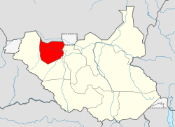
Northern Bahr el Ghazal
Northern Bahr el Ghazal | |
|---|---|
 Location in South Sudan. | |
| Coordinates: 08°44′N 26°54′E / 8.733°N 26.900°E | |
| Country | |
| Region | Bahr el Ghazal |
| Capital | Aweil |
| Area | |
| • Total | 30,543.30 km2 (11,792.83 sq mi) |
| Population (2008) | |
| • Total | 720,898 |
| • Density | 24/km2 (61/sq mi) |
| Time zone | UTC+3 (EAT) |
| HDI (2018) | 0.333[1] low · 10th of 10 |

Northern Bahr el Ghazal is a state in South Sudan. It has an area of 30,543 km²[2] and is part of the Bahr el Ghazal region. It borders South Darfur to the north, Western Bahr el Ghazal to the west and south, and Warrap and Abyei to the east. Aweil is the capital of the state.
History
Because of its proximity to Kordofan and the presence of a railway line through it to Wau, it suffered extensively in the 1983–2005 civil war in southern Sudan. North Bahr al Ghazal and adjacent parts of Western Kordofan to the north were among the most politically sensitive regions in Sudan. Missriya Arabs from Kordofan have interacted with Dinka in this region over a long time. While relations during the colonial era were largely peaceful, the war saw an upsurge in hostilities. Government backing to the Missriya gave them a decided advantage over local Dinka groups, and raiding by murahileen militias (and other government backed groups, including some Dinka militias) resulted in considerable loss of life, widespread abduction and pillaging of Dinka villages. Many of these raids coincided with the movement of government trains to and from Kordofan to Wau.
It had the highest rate of poverty, 76% according to government statistics, of the 10 states of South Sudan.[3]
Government
Retired Gen. Salva Chol Ayat was the last Acting governor of the state. He replaced Kuel Aguer Kuel in April 2015.
Administration
Northern Bahr al Ghazal, like other states in South Sudan, is divided into counties; there are five counties, headed by a County Commissioner, as detailed below:[4]
| County | Area (km2) | Population Census 2008 |
County Headquarter |
|---|---|---|---|
| Aweil North | 6,376.53 | 129,127 | Gok Machar |
| Aweil East | 6,172.23 | 309,921 | Wanyjok |
| Aweil South | 1,786.95 | 73,806 | Malek Alel |
| Aweil West | 5,030.22 | 166,217 | Nyamlell |
| Aweil Central | 11,177.40 | 41,827 | Aweil |
The counties are further divided into Payams, then Bomas.
References
- ^ "Sub-national HDI - Area Database - Global Data Lab". hdi.globaldatalab.org. Retrieved 2020-04-18.
- ^ "Northern Bahr El Ghazal". South Sudan Disarmament, Demobilisation and Reintegration Commission. Archived from the original on 2011-07-14. Retrieved 2011-07-08.
- ^ "In pictures: The life of a nurse in South Sudan". bbcnews.com. 23 September 2012. Retrieved 29 December 2013.
- ^ 2008 South Sudan Population Ma By County
Books
- Francis M. Deng, 1995, War of Visions, Conflict of Identities in the Sudan, (Washington D.C.: Brookings)
- Human Rights Watch, 1999, Famine in Sudan, 1998, The Human Rights Causes, (New York, Human Rights Watch).
- Dave Eggers, 2006, What is the What, (New York, Vintage Books).
- David Keen, 1994, The Benefits of Famine, A Political Economy of Famine and Relief in Southwestern Sudan, 1983–1989, (New Jersey, Princeton University Press).
- Garang Malong, 2012, Theatre of Hope( Nairobi University, Kenya)
- Aweil graduates network( 2013)
External links
- John Ryle, Jok Madut Jok and Fergus Boyle, 2003, Sudan Abduction and Slavery Project, Abductee Database 2003 Report
- "Northern Bahr el Ghazal State gets in new cabinet" [1][permanent dead link]

